Jul 6, 2025
20
mins read
India’s climate is dominated by the Indian monsoon system, defined by a seasonal reversal of prevailing winds and alternating wet and dry seasons. In India, the southwest monsoon (mid-June–September) brings most of the rain, whereas the northeast (retreating) monsoon (October–December) is drier and mainly affects the southeast coast. The southwest Indian monsoon system accounts for roughly 75% of India’s annual rainfall, making it the lifeblood of agriculture and water supply. Seasonal reversal means winds blow from sea to land in summer and from land to sea in winter. Indian Monsoons transform India’s landscape: good years yield bumper crops, while poor monsoons cause droughts or floods. Understanding this phenomenon – its mechanisms, patterns, and impacts – is critical for UPSC aspirants, as evidenced by frequent UPSC questions on monsoons.
The core mechanism of Indian monsoons arises from differential heating of land and sea. In summer, the Sun’s overhead move to the Tropic of Cancer heats the Indian landmass and the Tibetan Plateau intensely, creating a vast low-pressure zone (heat source) over Asia. Surrounding oceans (Indian Ocean, Bay of Bengal, Arabian Sea) remain relatively cooler and form heat sinks, including the Mascarene High near Madagascar. Indian Monsoon winds blow from these oceanic high-pressure (cold) regions toward the heated land (low pressure). Upper-atmosphere circulation is also crucial: a strong easterly jet stream forms over northern India in summer, while in winter a westerly subtropical jet resumes, driving the reversal of wind patterns. In short, the thermal contrast between the warm continent and cooler oceans sets up the monsoon circulation.
Factors Affecting Indian Monsoons
Key factors influencing the strength and timing of Indian monsoons include:
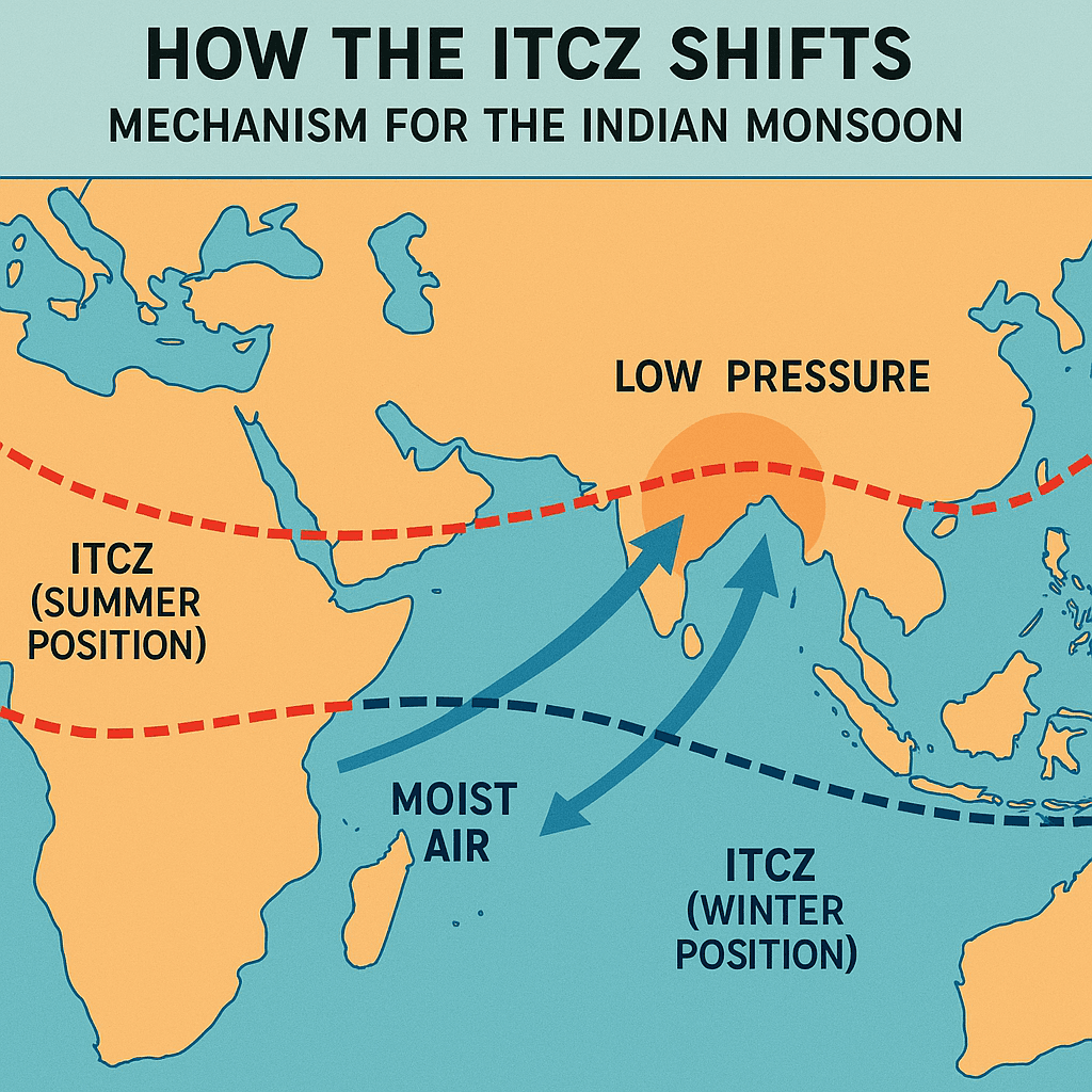
Inter-Tropical Convergence Zone (ITCZ): The ITCZ is the belt of rising air near the equator where trade winds converge. In summer it shifts north to about 20°–25°N (over the Indo-Gangetic Plain), aligning with the monsoon trough and bringing widespread rain. The seasonal northward shift of the ITCZ (also called the Monsoon Trough) concentrates heavy rains over northern India in July.
Tibetan Plateau and Himalayas: Summer heating of the plateau induces a strong low-pressure area aloft. Conversely, in winter a cold anticyclone (high pressure) forms over Tibet/Siberia that drives the Northeast Indian monsoon back toward the Indian Ocean. The Himalayas block cold Central Asian winds and funnel monsoon moisture along the plains, also preventing monsoon rains from reaching Central Asia.
Jet Streams: The Tropical Easterly Jet (around 14 km altitude) emerges over India in summer, aiding monsoon onset; the Subtropical Westerly Jet shifts northward in winter. These high-altitude winds help ventilate heat off the land and can trigger the “burst” of the monsoon.
Somali Jet (Findlater Jet): A low-level jet over the Arabian Sea that accelerates moisture transport toward the west coast of India. Its strength can modulate rainfall over western India.
Oceanic Conditions: Sea surface temperatures (SSTs) in the Indian Ocean, Arabian Sea and Bay of Bengal critically affect moisture content. A warm Indian Ocean enhances monsoon rains, while phenomena like the Indian Ocean Dipole (IOD) can shift winds and rainfall patterns between east and west Indian Ocean. El Niño–Southern Oscillation (ENSO) is a key teleconnection: El Niño years tend to weaken the southwest monsoon (by altering Walker circulation), whereas La Niña tends to strengthen it.
Table of content
The Indian Ocean Dipole (IOD) is a climate phenomenon that causes alternating SST patterns between the western and eastern Indian Ocean. It plays a critical role in Indian monsoons, especially the southwest monsoon. The given tables explain the impact and features of positive and negative IOD.

Positive IOD (+IOD)
Feature | Impact on Indian Monsoon |
Warmer western Indian Ocean (near East Africa) | Enhances Arabian Sea moisture transport |
Cooler eastern Indian Ocean (near Indonesia) | Suppresses convection there, redirecting it to India |
Monsoon Effect | Stronger southwest monsoon, especially over western and central India |
Negative IOD (–IOD)
Feature | Impact on Indian Monsoon |
Warmer eastern Indian Ocean | Stronger convection over Indonesia and Australia |
Cooler western Indian Ocean | Less moisture for monsoon winds in India |
Monsoon Effect | Weaker Indian monsoon, lower rainfall, especially in western India |
The surrounding oceans - especially the Indian Ocean, Arabian Sea, and Bay of Bengal - act as critical moisture sources and climatic regulators for the Indian Monsoons.
Ocean-Driven Nature of the Southwest Monsoon
The Southwest Monsoon (June–September), a major component of types of monsoon in India, is essentially ocean-driven.
Monsoon winds in India, originating from the Arabian Sea and Bay of Bengal, carry moisture-laden air toward the Indian landmass.
These winds are a part of the seasonal reversal of wind systems driven by land-sea thermal contrast.
Role of High-Pressure Systems
The Mascarene High, a permanent high-pressure cell located east of Madagascar over the southern Indian Ocean, plays a pivotal role.
It draws moist air northward, fueling the southwest monsoon.
The strength and position of this cell regulate monsoon intensity.
Influence of SST Anomalies and Oceanic Patterns on Indian Monsoon UPSC
Oceanic Phenomenon | Impact on Indian Monsoon | UPSC Relevance |
Warm SSTs | Enhance evaporation and cloud formation | Frequently asked in prelims |
Positive Indian Ocean Dipole (IOD) | Warmer western Indian Ocean strengthens monsoon winds in India | PYQs on IOD and Monsoon link |
El Niño (Pacific) | Suppresses Indian monsoon’s activity | 2015, 2016 Prelims |
La Niña | Enhances Indian monsoon’s performance | 2021 Prelims |
Cold Currents | Reduce monsoon cloud moisture | Add to unpredictability |
Example: In 2019, a strong positive IOD enhanced Indian monsoon rainfall, especially over the western coast.However, El Niño conditions occurring simultaneously weakened the monsoon in central and eastern India.
Ocean Currents and Indian Monsoon Linkage
The Somali Current, a monsoon-driven ocean current off the East African coast, directly enhances moisture transport toward the Indian subcontinent.
Changes in this current can advance or delay monsoon onset — an important aspect in monsoon UPSC case studies.
Ocean-Atmosphere Feedback Loops
The Indian monsoon is sensitive to shifts in sea surface temperatures (SSTs), especially in the Indian Ocean.
These ocean-atmosphere feedbacks control monsoon vigor:
High SSTs → Increased evaporation → Stronger monsoon clouds
Weak SSTs or El Niño → Dry spells or monsoon failures
India experiences two types of monsoonal seasons:
Southwest Monsoon in India
The southwest monsoon is the most prominent and rain-bearing phase of the Indian monsoons, playing a vital role in India’s agriculture, economy, and climate. It is frequently covered in monsoon UPSC questions.
Duration: June to September (peak summer season)
Onset of the South-West Monsoon Mechanism and Wind Direction
Indian monsoons are driven by the seasonal shift of the Inter-Tropical Convergence Zone (ITCZ), which moves north and south with the apparent movement of the Sun.
In June and July, as the Sun shines over the Tropic of Cancer, the ITCZ shifts to 20°–25°N, forming the Monsoon Trough over the Indo-Gangetic Plain.
This shift triggers the onset of the southwest monsoon due to intense heating over northwestern India and cooler temperatures over the Indian Ocean, creating a strong pressure gradient.
The southwest monsoon winds in India, originating as southeast trade winds, cross the equator and change direction due to the Coriolis force, gathering moisture from the Indian Ocean.
The easterly jet stream (Somali Jet) sets in along 15°N after the westerly jet stream withdraws from northern India, aiding the monsoon burst.
These monsoon winds in India are further influenced by the country's relief and thermal low pressure over northwest India.
Branches of Southwest Monsoon
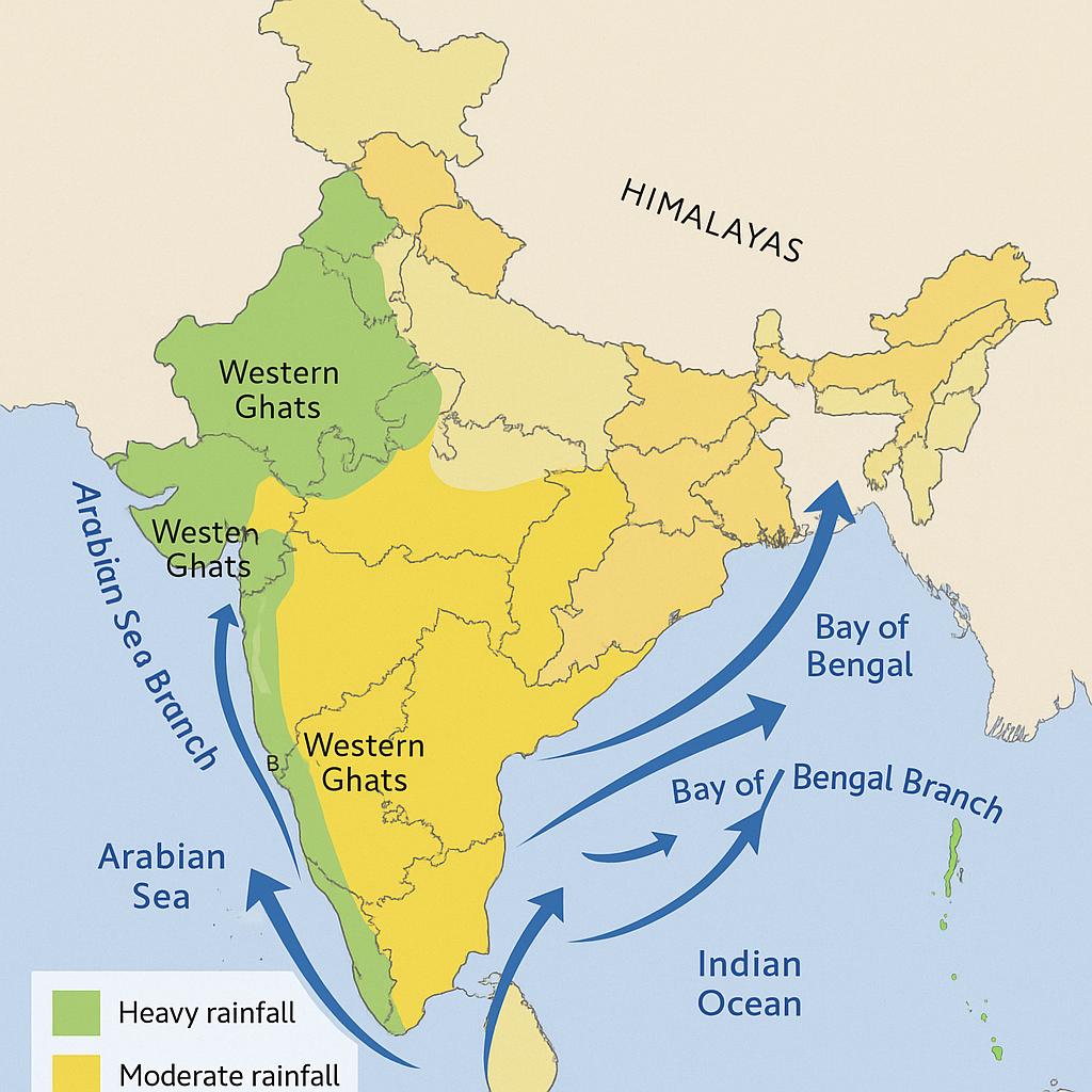
The two branches of the southwest monsoon hit India after crossing the Equator and deflecting due to the Coriolis force:
Branch | Route & Impact |
Arabian Sea Branch | Hits the Western Ghats; causes heavy rainfall in Kerala, Karnataka, Konkan, Goa, and Mumbai |
Bay of Bengal Branch | Moves towards the northeast; strikes the Himalayas and causes rainfall in West Bengal, Assam, and later North India |
Regional Rainfall Distribution
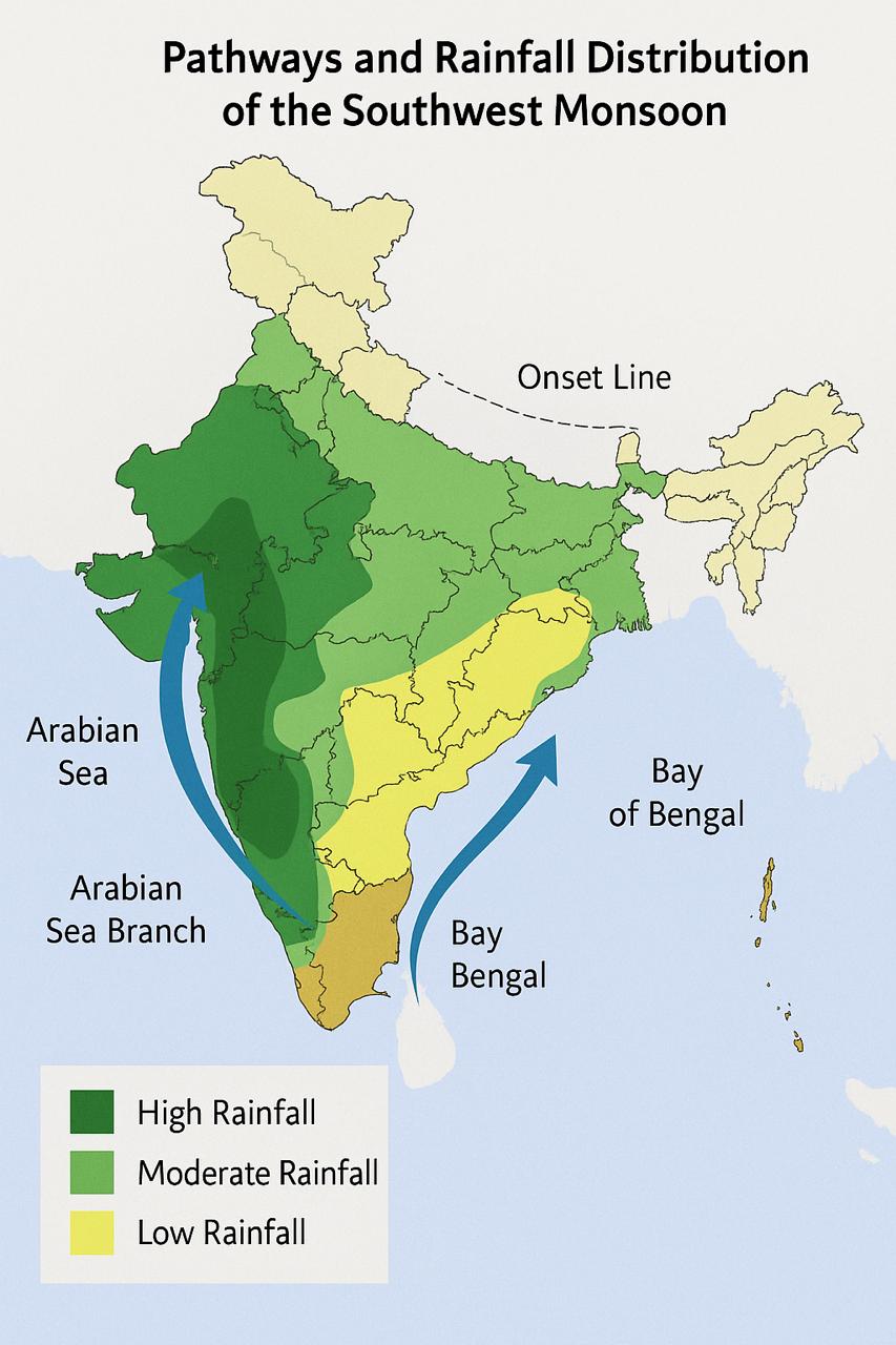
Region | Rainfall Pattern |
Western Ghats (Windward) | Heavy orographic rainfall |
Deccan Plateau (Leeward) | Less rainfall due to rain shadow effect |
Indo-Gangetic Plain | Widespread moderate to heavy rainfall |
Rajasthan & Gujarat | Low rainfall; often semi-arid |
Significance of the Southwest Monsoon
Provides over 70% of India’s annual rainfall.
Critical for Kharif crops like rice, maize, pulses, and cotton.
Refills reservoirs and groundwater—vital for drinking water and irrigation.
Any failure or delay has a direct impact on the Indian economy and food security
Northeast Monsoon (Retreating Monsoon)
The northeast monsoon is one of the two main types of monsoon in India. Unlike the southwest monsoon, this season is shorter and region-specific.
Key Features of the Northeast Monsoon
Time Period: October to December (late autumn to early winter).
Wind Direction: Dry, cool winds blow from northeast to southwest, hence called the northeast monsoon winds in India.
Origin: These winds arise due to:
High-pressure system over the cold Asian landmass.
Low-pressure belt over the southern Indian Ocean near the equator.
Moisture Source and Rainfall Mechanism
Though initially dry, these winds gain moisture over the Bay of Bengal.
They deliver rainfall to:
Tamil Nadu (receives ~48% of its annual rainfall from this monsoon).
Southeastern coast of Peninsular India.
Regional Impact
Region | Impact |
Tamil Nadu & Coastal A.P. | Heavy rainfall, crucial for agriculture |
Northern India | Mostly dry; considered the dry season |
India has a tropical monsoon climate, but with significant regional diversity. The broad effect is unity (wet summers, dry winters across India), but local geography causes variations. For example, Kerala’s climate (wet all monsoon) differs drastically from Tamil Nadu’s (dry in southwest monsoon, wet in northeast monsoon). Key variations include:
Orographic influences: Mountains alter rainfall. The Himalayas block northward movement of rain-bearing clouds. The Western Ghats intercept the Arabian Sea branch, causing lush rains on the west coast (7000+ mm in some hills), and aridity on the eastern leeward side (rain-shadow). The Eastern Ghats have a similar, but smaller effect on the Bay of Bengal branch.
Windward vs Leeward: Assam and Meghalaya hills (windward to Bay branch) receive massive rainfall (e.g. 11,430 mm at Cherrapunji), whereas Punjab and western Rajasthan (leeward to both branches) get very little.
Temperature range: Coastal regions have a smaller annual temperature range than the interiors. For instance, Thiruvananthapuram swings only ~2–3°C annually, while northwestern India can vary ~75°C seasonally.
Seasonal patterns: India effectively has three seasons (summer monsoon, retreating monsoon, and a hot pre-monsoon), rather than the four temperate seasons. The monsoon climate’s hottest (pre-monsoon) and coolest (winter) periods are defined by rainfall patterns.
Overall, Indian monsoon rains and temperatures vary greatly across regions. High-altitude and coastal areas have milder temperatures and reliable rains, while inland plains endure hotter summers and more variable rainfall. These regional traits must be considered in planning agriculture, water resources, and disaster management.
Southwest Monsoon Flow
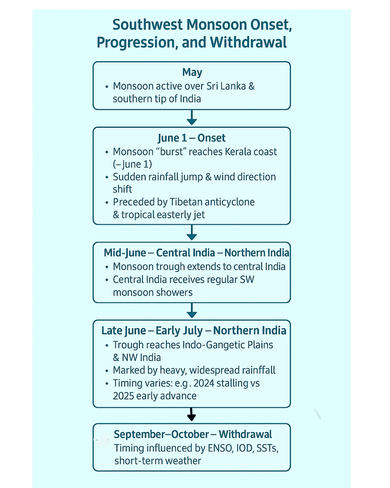
Onset begins around June 1 over Kerala, marked by a surge in rainfall and wind reversal.
By mid-June, it covers central India; by early July, it reaches the Indo-Gangetic Plains.
The system is preceded by Tibetan anticyclone and tropical easterly jet, linking it to upper-atmospheric circulation.
In May, the monsoon is already active over Sri Lanka and southern tip of India.
Progress varies annually:
2024: Delayed progress → 20% deficit by mid-June
2025: Early advance over northern India by late June
Withdrawal starts in September, completed by early December from Kerala.
Influencing factors include ENSO, IOD, sea surface temperatures, and short-term weather patterns.
Begins in October–November, when southwest monsoon winds weaken and start to withdraw from North India.
Characterized by clear skies, moist soil, rising day temperatures, and high humidity, leading to the oppressive “October heat”.
In mid to late October, daytime temperatures stay high while nights cool, and the mercury begins to drop sharply, especially across northern India.
During this phase, North India sees dry weather, but the eastern Peninsula, especially the Coromandel Coast, receives rain via cyclonic depressions from the Andaman Sea.
These systems sometimes intensify into tropical cyclones, bringing heavy, widespread rainfall—and are notoriously destructive.
October and November become the rainiest months for eastern Tamil Nadu, Andhra Pradesh, and Tamil Nadu due to the northeast (winter) monsoon.
Contrasting this, the rest of India largely depends on the June–September southwest monsoon, while the northeast monsoon is vital for agriculture and water security in South India.
Accurate forecasting of the Indian monsoon is essential for agriculture, disaster preparedness, and economic stability. The India Meteorological Department (IMD) and allied agencies continuously refine their forecasting systems to address the complexities of monsoon winds in India.
Forecasting Techniques Used by IMD
Statistical Models: Use historical data patterns to predict seasonal rainfall.
Dynamical Climate Models: Simulate atmosphere–ocean interactions.
Analog Methods: Compare with previous similar climate years.
Recent Advances in IMD Forecasting
Forecast accuracy improved by ~40–50% (due to better models & computing).
Extended-range forecasts: 4-week rainfall outlooks help farmers plan sowing and irrigation.
Use of AI & data assimilation: For localised event prediction.
Enhanced infrastructure: Doppler radars, satellites, and supercomputers.
Challenges Due to Climate Change
Increased variability and extremes → Reduced predictability.
Localized weather events (e.g., cloudbursts, flash floods) are harder to model.
IMD adapts with refined models, real-time data, and early-warning systems.
Agricultural & Economic Dimensions
About 50% of India’s net cultivated land is rain-fed, contributing roughly 40% of the country’s food basket.
Agriculture employs ~56% of the workforce, contributing ~16–19% to GDP.
Monsoon rains replenish ~70% of India’s water supply (reservoirs, rivers, groundwater) — according to IMD and major studies .
Sowing and outputs: Adequate Indian monsoons yield strong kharif crop harvests; erratic monsoons trigger reduced sown area and crop yields (e.g., 2002 saw 22% rainfall deficit → drop in paddy (3.7 Mha), pulses (1.96 Mha), oilseeds (1.15 Mha), and cotton (2.46 Mha)).
Water management: India’s irrigation coverage jumped from 42% in 2016–17 to 52% in 2022–23, increasing food grain production from 272 MT to 329.7 MT.
Environmental & Disaster - Impact of Indian Monsoons
Floods: Monsoonal floods regularly affect states like Assam, Bihar, UP, Kerala, Maharashtra, and West Bengal. Notable floods include:
Erosion & landslides: Hill regions in Himachal, Uttarakhand, NE India are particularly vulnerable during prolonged rain phases.
Droughts: Prolonged monsoon failure leads to degradation in Bundelkhand, Marathwada, Rajasthan, parts of MP & Karnataka.
Cyclones: Monsoon-active Bay of Bengal regions (Odisha, AP, Bengal) frequently endure devastating cyclones.
Hazard | Cause | Affected Regions & States |
Flooding | Heavy monsoon rains | Assam, Bihar, Uttar Pradesh, Kerala, Maharashtra, WB |
Landslides | Saturated hills | Uttarakhand, Himachal, NE states |
Erosion | Surface runoff | MP, Jharkhand, Odisha |
Drought | Monsoon failure/delay | Rajasthan, Gujarat, Maharashtra (Marathwada/Vidarbha), Karnataka |
Cyclones | Ocean-land interaction | Andhra Pradesh, Odisha, Tamil Nadu, West Bengal |
Reducing monsoon-related risks requires integrated planning:
Forecasting & Early Warning: Improved monsoon forecasts (seasonal to nowcast) and timely alerts for cyclones or heavy rains help authorities prepare. For instance, IMD’s sub-division-level bulletins and Panchayat-level outreach (e.g. Panchayat Mausam Sewa) aims to deliver rain forecasts to farmers. Early warnings can trigger flood-control measures (reservoir management, evacuation).
Water Management: Building dams, check-dams and recharge structures helps capture monsoon runoff for use in the dry season, reducing flood peaks and drought severity. India’s river basin management projects aim to control floods and distribute monsoon waters.
Agricultural Adaptation: Crop insurance schemes (PMFBY), drought-resistant crop varieties, and flexible cropping schedules (e.g. adjusted planting based on weekly forecasts) help buffer farmers. For example, farmers are advised to sow paddy only after monsoon onset to avoid crop failure.
Disaster Preparedness: Urban planning (stormwater drains, no-construction zones in floodplains) and capacity-building for disaster response (NDRF, NDMA) mitigate losses. For instance, IMD’s warning of floods in the 2025 monsoon (Uttarakhand, Haryana, etc.) prompted pre-monsoon reservoir releases.
Climate Resilience: In the face of climate change, India is emphasizing resilient infrastructure (e.g. flood walls) and afforestation to stabilize slopes. International cooperation on ocean observation and monsoon research (ICPOs, climate models) also supports long-term mitigation.
Continued investment in research (e.g. ISRO’s satellite missions) and sustainable practices is needed. Even with uncertainties, a combination of better prediction, smart policy, and community preparedness can reduce the negative fallout of monsoons on society.
Monsoon Mission of India (MoES, 2012)
Aims to improve seasonal, intra-seasonal, and medium-range monsoon forecasts via dynamic modeling and data assimilation.
Supports observational programs and collaborations with IITM–Pune, NCMRWF, IMD, and international partners.
Economic analysis estimates budget at approx. ₹551 crore for better predictive accuracy.
Mission Mausam (recent MoES push)
Equipped with 37+ Doppler weather radars and dense observation networks; integrates AI/ML and improved forecasting models (e.g., Bharat Forecast System at 6 km resolution)
Bharat Forecasting System (May 2025)
Developed by IMD & IITM, this high-resolution (6 km grid) system enhances medium- and short-range weather prediction nationally
Supercomputing Infrastructure
High-performance systems like Pratyush & Mihir (total 6.8 PFLOPS) at IITM and NCMRWF support advanced climate modeling and monsoon prediction.
National Supercomputing Mission (NSM) enables local decision support systems—e.g., flood forecasting in Pimpri-Chinchwad—for urban resilience.
Indo–US Oceanographic Expedition (2018)
ORV Sagar Nidhi mission across Bay of Bengal gathered ocean–atmosphere data to refine models on monsoon variability
Flood Forecasting & Urban Modelling
C‑FLOOD system and sub‑division bulletins support water management via early warnings (IMD & CWC).
Local-scale systems like PCMC–C‑DAC’s 72-hour forecasting aid municipal-level planning
Q.What are Indian Monsoons and why are they important?
A.Indian monsoons refer to the seasonal reversal of winds that bring wet and dry spells across India. The southwest monsoon (June–September) and northeast monsoon (October–December) are the two major types. They are vital for agriculture, water supply, and economic stability, making them a core topic for Indian Monsoon UPSC preparation.
Q.What are the two types of monsoon in India?
A. There are two major types of monsoon in India:
1. Southwest Monsoon (Summer Monsoon): June to September – brings over 70% of India's rainfall.
2.Northeast Monsoon (Retreating Monsoon): October to December – affects Tamil Nadu and southeast coast.
These distinctions are crucial for answering monsoon UPSC questions accurately.
Q.How do monsoon winds in India work?
A. Monsoon winds in India are driven by the differential heating of land and ocean:
- In summer, low pressure over land draws moist winds from the Indian Ocean, causing rainfall.
- In winter, the winds reverse — dry, cold air moves from land to sea.
This wind reversal defines the monsoon system and is frequently tested in UPSC Geography.
Q.What is the role of oceans in Indian monsoon formation?
A.The Indian Ocean, Bay of Bengal, and Arabian Sea provide the moisture required for monsoon rains. Warm sea surface temperatures (SSTs) and systems like the Mascarene High enhance monsoon winds in India, while global patterns like ENSO and IOD influence rainfall variability.
India’s monsoon is a complex, vital phenomenon that shapes the nation’s climate, agriculture, and economy. It is governed by large-scale climate interactions – land-sea temperature contrasts, ITCZ shifts, jet streams, and oceanic conditions – as well as regional geography. While past understanding (e.g. Halley’s theory) focused on thermal contrasts, modern science also examines teleconnections (ENSO/IOD) and climate change impacts. UPSC aspirants must grasp both the physical mechanisms and practical implications (floods, droughts, forecasting) of monsoons.
Internal Linking Suggestions
How to Begin Your UPSC Preparation : The Ultimate Guide For Beginners
UPSC Previous Year Question Papers with Answers PDF - Prelims & Mains (2014-2024)
upsc optional subject list and syllabus-for-cse-exam-2025-complete-guide
How to Prepare Current Affairs for UPSC Exam: A Comprehensive Guide
51st G7 Summit 2025 – Countries, Key Issues, India’s Role & UPSC
External Linking Suggestions
UPSC Official Website – Syllabus & Notification: https://upsc.gov.in/
Press Information Bureau – Government Announcements: https://pib.gov.in/
NCERT Official Website – Standard Books for UPSC: https://ncert.nic.in/