Aug 13, 2025
12
mins read
What is the pacific ring of fire?
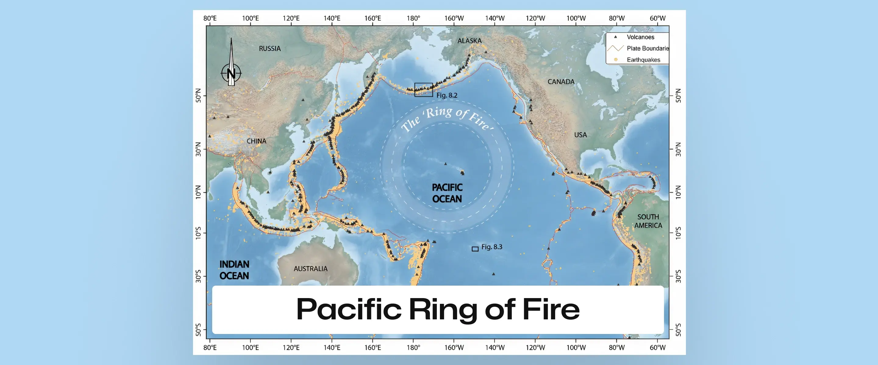
The Pacific Ring of Fire is a roughly 40,000 km long horseshoe of volcanic and seismic activity encircling the Pacific Ocean. It contains the majority of Earth’s active volcanoes (about 75%) and nearly 90% of its largest earthquakes This intense activity arises from plate tectonics: the Pacific Plate is subducting beneath surrounding plates (e.g. North American, Nazca, Philippine), producing magma and faulting. The result is deep ocean trenches, volcanic arcs and frequent earthquakes along the Pacific margins.

Between July 10 and 28, 2025, the Pacific Ring of Fire experienced heightened seismic activity with significant eruptions at Japan’s Sakurajima and Indonesia’s Semeru volcanoes.
Earthquakes included a magnitude 6.2 tremor in Japan and a 5.8 quake in the Philippines, causing alerts and disruptions.
Taal Volcano in the Philippines emitted gas plumes, resulting in raised alert levels and precautions.
Chile’s Villarrica volcano showed increased seismic swarms, indicating potential activity.
Table of content
Extent: The Ring of Fire spans the Pacific Ocean’s rim – along the western coasts of South and North America, across the Aleutian Islands (Alaska), then down eastern Asia past Japan and the Philippines to New Zealand and Antarctica.
Shape: It is ~40,000 km long and roughly horseshoe-shaped (not a perfect circle), tracing plate boundaries around the Pacific.
Features: The zone includes deep ocean trenches (e.g. Mariana, Peru–Chile) and volcanic island/mountain chains (e.g. Andes, Japan, Aleutians).
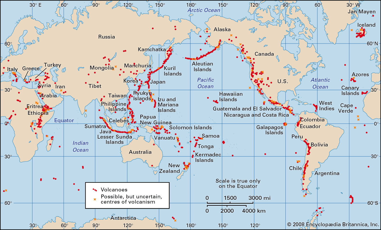
Which countries are located along the Ring of Fire?
The Ring of Fire encompasses several countries, including:North America: United States, Canada, Mexico
Central America: Guatemala, El Salvador, Nicaragua, Costa Rica, Panama
South America: Chile, Peru, Ecuador, Colombia
Asia: Russia, Japan, Philippines, Indonesia, Papua New Guinea, New Zealand
Oceania: Several island nations, including Tonga, Samoa, and Fiji
The Ring’s activity is driven by converging plates.
Key interactions include:
the Nazca Plate subducting beneath South America (creating the Peru–Chile trench and Andes)
the Pacific Plate under Eurasia (Aleutian–Kamchatka and Japan trenches)
the Pacific Plate under the Philippine/Indo-Australian Plates (Indonesia, Tonga arcs)
Pacific–North America transform contact (San Andreas Fault in California).
These boundaries concentrate deformation, earthquakes and volcanism.
Plate Boundaries
Boundary Type | Example Location | Effects on Ring of Fire |
Convergent (Subduction) | Nazca plate under South America (Peru–Chile Trench/Andes); Pacific under Eurasia (Japan/Kurils) | Deep trenches; volcanic mountain arcs (e.g. Andes, Japan) |
Divergent | Pacific–Nazca/Cocos (East Pacific Rise) | Seafloor spreading; creation of new crust and volcanic activity along ridges |
Transform (Slip) | Pacific–North America (San Andreas Fault, California) | Lateral motion; frequent earthquakes without volcanism |
Earthquake Activity
Frequency: About 90% of the world’s earthquakes occur in the Ring of Fire.
Historic quakes: It includes some of history’s largest quakes: 1960 Chile (M9.5), 1964 Alaska (M9.2), 2004 Sumatra (M9.1), 2011 Japan (M9.0).
Seismic impact: Many quakes are shallow and powerful, often generating tsunamis. Smaller tremors happen daily in places, reflecting constant tectonic stress.
Volcanic Activity
Volcano count: The Ring of Fire hosts 450+ volcanoes (∼75% of Earth’s active volcanoes).
Frequent eruptions: Notable events include Indonesia’s Tambora (1815, largest VEI 7 eruption) and Krakatoa (1883), plus the Philippines’ Pinatubo (1991). These produced global climate effects (e.g. Pinatubo’s SO₂ cooled Earth by ~1.3°F).
Famous volcanoes: Examples: Mount Fuji (Japan’s iconic stratovolcano), Mount St. Helens (USA, erupted 1980), Popocatépetl (Mexico). Many volcanoes in this belt erupt frequently, posing hazards to nearby populations.
Oceanic Trenches
Deep ocean trenches line the Ring of Fire where plates dive under others. The Mariana Trench (western Pacific) is ~11,000 m deep – the deepest point on Earth. Other major trenches include the Philippine, Kuril–Kamchatka, Peru–Chile and Tonga trenches. These trenches sit adjacent to volcanic arcs (e.g. Mariana Islands, Aleutians) and mark zones of intense seismicity.
Mariana Trench: ~10,994 m deep (≈7 miles).
Other trenches: Philippine, Challenger (Mariana), Kuril–Kamchatka, Peru–Chile, Tonga.
Tsunamis and Coastal Erosion
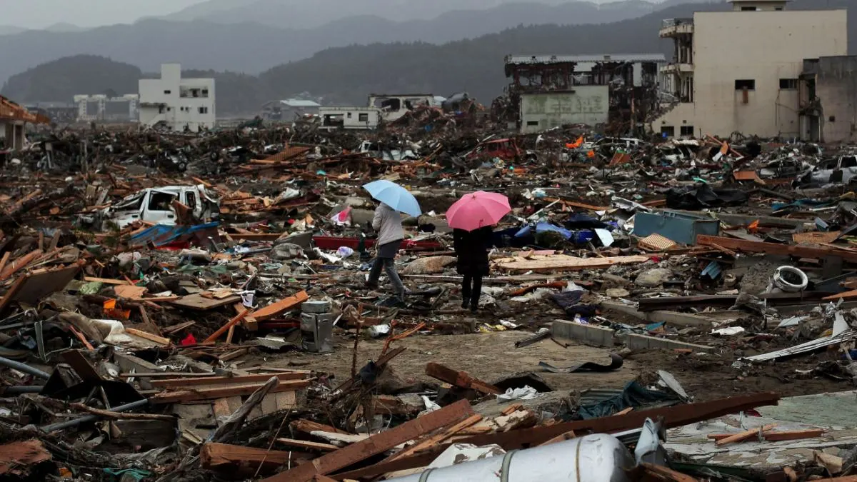
Subduction quakes in the Ring often trigger tsunamis: e.g. the 2004 Sumatra tsunami (M9.1 Indian Ocean quake) and 2011 Japan tsunami (M9.0) were caused by Ring earthquakes. Such waves cause catastrophic coastal flooding and damage.
Tsunami waves can erode shorelines and sweep away structures. Coastal erosion is also a chronic issue: strong waves, storms and rising seas gradually wear down coasts, compounding disaster impact in these regions.
Read more about Tsunamis and causes of Tsunami especially along the Ring of Fire : Tsunami UPSC, Meaning, Characteristics, Causes, Impacts & Mitigation Measures
Cities at risk:
Many major cities lie on the Ring: Tokyo (~38M), Manila, San Francisco, Los Angeles, Mexico City (~20M near Popocatépetl), Santiago, Lima, etc. This puts large populations in earthquake/eruption danger.
For instance, Popocatépetl volcano in Mexico threatens ~20 million residents in Mexico City and Puebla.
Communities:
Coastal and island populations (e.g. in Indonesia, Philippines, Pacific Islands) are repeatedly exposed to quakes and tsunamis.
Indigenous and rural communities (Andean, Ainu, Pacific islanders) have traditional coping strategies, but also face repeated resettlement after disasters.
Geothermal energy:
The Ring’s heat resources are huge – it holds >40% of the world’s geothermal potential.
By 2015, about 6 GW of geothermal power was installed in Ring countries (e.g. Philippines, Indonesia, New Zealand, USA). This provides renewable power and economic benefits.
Tourism:
Volcanic landscapes and related attractions (hot springs, geysers) draw tourists (e.g. Hawaii’s volcanoes, New Zealand’s Rotorua, Japanese onsens).
At the same time, disasters (like eruptions or quakes) can disrupt tourism.
Ports and shipping:
Major Pacific ports (Tokyo, Valparaiso, Seattle, Singapore via Malacca Strait) are near tectonic hazards.
Quakes/tsunamis can shut ports and shipping routes, impacting global trade.
Agriculture and mining:
Volcanic soils are fertile (good for crops like rice, coffee) but at risk from ash. Also, many mineral deposits (copper, gold, geothermal brines) form in arc zones.
Mining industries in Chile, Indonesia, etc. rely on these resources, which are also vulnerable to geological disruptions.
Warning systems:
Pacific nations use extensive seismic/tsunami alert networks.
For example, after a July 2025 Kamchatka quake (M8.8), Japan and Hawaii ordered evacuations, and Russia reported no casualties—crediting strong building codes and alert systems.
Preparedness:
Regular drills, evacuation plans, and education are routine in many Ring countries (especially Japan, USA, Indonesia).
Early warning centers (e.g. Pacific Tsunami Warning Center) monitor tsunamis and notify dozens of countries.
Infrastructure:
Building codes have been strengthened in quake-prone areas (e.g. Japan’s strict standards after the 1995 Kobe quake).
Post-disaster aid and reconstruction funds (often international) are mobilized to restore essential services and housing.
Formation: The Ring’s roots go back to the breakup of the supercontinent Pangaea (~200 million years ago) when the Pacific Ocean opened. Ongoing plate motions since then carved out the present-day trenches and arcs.
Mountain building: Repeated subduction over geological time built ranges like the Andes, Cascades, Aleutians, and Japanese archipelago. Each major plate collision added or uplifted new volcanoes.
Historic quakes: The region has seen ancient mega-events. For instance, two great megathrust earthquakes (~M9.3 in 1737 and M8.2 in 1952) struck off Kamchatka. Prehistoric super-eruptions (e.g. Indonesia’s Toba ~74,000 years ago) also occurred in this belt (evidence from ash layers worldwide). These events have shaped the global climate and ecosystems over millennia.
Q. What is the pacific ring of fire?
A. The Pacific Ring of Fire is a horseshoe-shaped zone around the Pacific Ocean with frequent earthquakes and many active volcanoes caused by tectonic plate subduction.
Q. What causes frequent volcanic eruptions around the Pacific Ocean?
A.The Pacific Ocean, especially along the Ring of Fire, is surrounded by subduction zones where tectonic plates collide. As the Pacific Plate is subducted beneath surrounding plates, intense heat and pressure generate magma, leading to frequent volcanic eruptions and the formation of volcanic arcs like the Aleutian Islands.
Q. Why is the Ring of Fire considered the most seismically active region on Earth?
A.The Ring of Fire is a seismically active region where several tectonic plates interact along complex plate boundaries, including convergent and transform boundaries. These interactions cause major earthquakes and build up earth's crust, making this circum-Pacific belt prone to dramatic seismic events.
Q. How do tectonic plates influence the formation of active volcanoes?
A.Tectonic plates, through the processes of plate tectonics, drive the movement of the earth’s crust. At convergent plate boundaries, when one plate is subducted beneath another, magma rises and leads to the formation of active volcanoes. Many of Earth’s active volcanoes are located in these zones.
Q. What are some key tectonic plates involved in the Pacific Ring of Fire?A.Major plates include the Pacific Plate, North American Plate, Philippine Plate, Cocos Plate, and South American Plate. These plates move along the western edge of the Americas and Asia, causing earthquakes, explosive eruptions, and reshaping the ocean floor and earth’s surface over time.
The Pacific Ring of Fire is a vast, dynamic zone of geologic risk and opportunity. It hosts most of Earth’s active volcanoes and largest earthquakes, shaping landscapes and affecting climate and economies. Coastal cities and island nations along the Ring must prepare for earthquakes, tsunamis and eruptions as part of daily life. However, this geologic engine also provides benefits: geothermal energy, fertile soils and mineral resources. Understanding this tectonic belt is essential for disaster planning and sustainable development. For more on earth science topics, see the Padhai resource center and related Padhai Blogs.
Internal Linking Suggestions
Tsunami UPSC, Meaning, Characteristics, Causes, Impacts & Mitigation Measures
How to Begin Your UPSC Preparation : The Ultimate Guide For Beginners
UPSC Previous Year Question Papers with Answers PDF - Prelims & Mains (2014-2024)
40 Most Important Supreme Court Judgements of India : Landmark Judgements UPSC
GST Council (Goods and Services Tax Council): Constitutional Provisions, Functions, Way Forward
External Linking Suggestions
UPSC Official Website – Syllabus & Notification: https://upsc.gov.in/
Press Information Bureau – Government Announcements: https://pib.gov.in/
NCERT Official Website – Standard Books for UPSC: https://ncert.nic.in