Mountain Passes in India: Map, Major Passes, State-Wise List

Gajendra Singh Godara
15
mins read

A mountain pass is a natural route through a mountain range that provides a lower and often more navigable path between valleys or over ridges. These passes commonly form where glaciers or rivers have eroded the mountains over time, creating saddle-like depressions in steep terrain.
They serve as essential corridors for trade, travel, and strategic movement, especially in the Himalayas where they connect different parts of India and neighbouring countries like China, Nepal, and Pakistan. Mountain passes have historically been crucial for facilitating cultural exchange, military campaigns, and economic activities across otherwise difficult mountainous landscapes.
Understanding Mountain Passes in India
If you look at any mountain passes in India map, you’ll notice these unique corridors cut through intimidating walls of rock. Mountain passes usually form where enormous glaciers or fast-flowing rivers have, over centuries, carved lower ‘saddles’ into otherwise steep mountain ranges.
This natural phenomenon results in the most navigable routes across some of India’s hardest terrain—places where ancient traders, soldiers, and even modern bikers found it easier to cross from one side of the Himalayas to the other.
Join our WhatsApp Community
State-Wise Mountain Passes in India
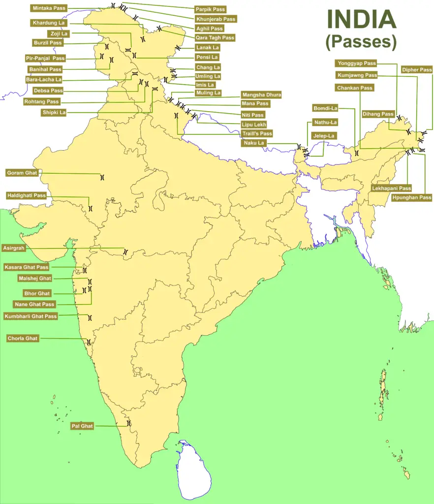
Jammu & Kashmir (UT)
Banihal Pass (2,832 m): Located on the Pir Panjal Range, it historically linked Jammu to the Kashmir Valley. The Jawahar Tunnel beneath Banihal now provides all-weather road connectivity.
Pir Panjal Pass (Peer Ki Gali, ~3,490 m): Also on the Pir Panjal Range, it connects the Kashmir Valley to the Jammu region (Rajouri and Poonch).
Zoji La (3,528 m): Connects Srinagar/Kashmir Valley with Leh (Ladakh) via NH1, currently Zoji La tunnel under construction.
Fotu La (4,108 m): Highest point on Srinagar-Leh highway; connects Kashmir to Ladakh sectors.
Namika La (3,700 m): On Srinagar-Leh national highway; connects Kashmir Valley to Ladakh plateau.
Ladakh (UT)
Khardung La (5,359 m): In the Ladakh Range north of Leh, it is the gateway to the Shyok and Nubra valleys. One of the world’s highest motorable roads, Khardung La is critical for military logistics (e.g. supplies to the Siachen sector).
Chang La (5,360 m): On the Ladakh Range between Leh and the Shyok River valley, it lies on the way to Pangong Tso.
Taglang La (5,328 m): On the Leh-Manali Highway, it is one of the highest motorable passes in India and connects Leh with western Himalaya.
Pensi La (4,400 m): The “gateway to Zanskar” in the Great Himalayas. It connects the Suru Valley (Kargil) with Zanskar Valley and is the source of the Suru River, an Indus tributary.
Karakoram Pass (5,540m): On the Ladakh-Kashmir border in the Karakoram Range, links Ladakh and Xinjiang, it was part of the ancient Silk Route between the Indian subcontinent.
Marsimik La (5582 m): High-altitude motorable pass linking Pangong Lake to Chang Chenmo Valley, serving as a critical military supply route near the LAC.
Rezang La (5,500 m): In Chushul sector, south of Pangong Lake; site of famous 1962 Indo-China war battle.
Bilafond La (5,450 m): In Saltoro Ridge west of Siachen Glacier; critical India-Pakistan border conflict zone.
Sia La (5,490 m): Near Siachen Glacier on India-Pakistan border; highest battleground in Operation Meghdoot.
Gyong La (5,680 m): South of Bilafond La in Saltoro Mountains; India-Pakistan strategic position.
Sasser Pass (5,411 m): Connects Nubra Valley to Shyok Valley; ancient Silk Route link to Yarkand.
Imis La (5,350 m): Near Siachen Glacier region; strategic pass in Siachen conflict zone.
Kongka Pass (5,171 m): On LAC in Chang Chenmo Valley; disputed India-China border crossing; site of 1959 Kongka Pass incident.
Lanak Pass (5,409 m): On LAC in Depsang Plains; critical India-China border point near Aksai Chin; heavily patrolled.
Spangur Gap (4,305 m): Strategic pass near Spanggur Tso lake; serves as India-China border crossing in Ladakh.
Parpik Pass (4,978 m): In Gilgit-Baltistan region; historic pass linking Ladakh with Xinjiang; on ancient trade routes.
Sin La (5,495 m): Strategic high-altitude pass on India-China border; military significance in Ladakh.
Khunjerab Pass (4,693 m): On Karakoram Highway connecting Pakistan-China; world's highest paved international border.
Mintaka Pass (4,709 m): North of Khunjerab on Karakoram Range; historic pass on ancient Silk Route.
Aghil Pass (4,885 m): Connects Ladakh to Xinjiang; part of old trade routes across Karakoram.
Himachal Pradesh
Rohtang Pass (3,978 m): On the eastern Pir Panjal Range, it links Kullu Valley to Lahaul-Spiti Valley via NH3 (the Leh-Manali Highway). The all-weather Atal Tunnel has been built under Rohtang, now allowing year-round travel on the Manali-Leh route.
Bara Lacha La (4,850 m): In the Zanskar Range, it connects Himachal’s Lahaul district to Ladakh’s Leh district along NH3.
Shipki La (3,930 m): On the India-Tibet border between Kinnaur district and Tibet’s Ngari.
Kunzum Pass (4,551 m): Connects Lahaul Valley to Spiti Valley; gate to Spiti via NH505.
Jalori Pass (3,120 m): Connects Kullu Valley to Shimla district; scenic Kullu-Shimla route.
Indrahar Pass (3,550 m): In Dhauladhar Range; historic trek route between Kangra and Chamba districts.
Chanshal Pass (3,680 m): Connects Rohru to Dodra-Kwar; important pass in Shimla region.
Sach Pass (4,400 m): High-altitude pass in Dhauladhar Range; connects Kangra to Chamba.
Debsa Pass (4,600 m): Discovered in 1995; scenic trekking pass linking Kullu to Spiti Valley.
Bohar Pass (4,530 m): In Dhauladhar Range; connects Kangra district across mountains.
Uttarakhand
Lipu Lekh (5,110 m): On the Nepal-India-China tripoint in Pithoragarh district, it links Uttarakhand to Tibet.
Mana Pass (5,545 m): Near Badrinath, it was India's highest motorable pass until Umling La opened in 2021.
Niti Pass (5,073 m): On the India-China border and historically served as an important trade route between both countries.
Kalindi Pass (5,950 m): High-altitude trekking pass; connects Garhwal Himalayas to Spiti Valley.
Traill's Pass (4,600 m): Connects Pindari Glacier to Milam Glacier; popular high-altitude trek.
Auden's Col (5,490 m): In Garhwal Himalayas; connects upper Kuari Pass trek route.
Lamkhaga Pass (5,050 m): Connects Uttarakhand to Himachal Pradesh; trekking route through Himalayas.
Mangsha Dhura (4,940 m): On Kailash Mansarovar pilgrimage route; connects to Lipu Lekh passes.
Sikkim
Nathu La (4,310 m): In the Dongkya Range, it connects Gangtok to Tibet.
Jelep La (4,267 m) : South of Nathu La, connects Sikkim to Lhasa via the Chumbi Valley.
Goecha La (4,940m): Gateway to Kanchenjunga Base Camp; popular high-altitude trekking destination.
Arunachal Pradesh
Bum La (4,520 m): At Tawang district’s border with Tibet.
Sela Pass (4,170 m): On the Tawang-Guwahati NH13, noted for Sela Lake near its summit.
Bomdi La (4,331 m): On west of Tawang district at NH13.
Pangsau Pass (1,136 m): In Changlang district present on the India-Myanmar border.
Diphu (Dihang) Pass (4,587 m): Near the India-China-Myanmar tri-junction.
Hpungan Pass (3,450 m): Connects Arunachal Pradesh to Myanmar; strategic India-Myanmar border link.
Kumjawng Pass (4,200 m): On Indo-China border in eastern Arunachal; strategic forward position.
Mayodia Pass (4,000 m): In Arunachal Pradesh near snow zone; India-China strategic border position.
Lekhapani Pass (3,100 m): Entry point to Stilwell Road; historic WWII supply route through Arunachal.
Dongkhala (4,100 m): In North Arunachal; strategic Indo-China border crossing point.
Rajasthan
Haldighati Darra (1,184 m) : A mountain pass in the Aravalli Range. Known for the 1576 Battle of Haldighati.
Maharashtra (Western Ghats)
Thal Ghat (585 m): Also called Kasara Ghat, on Mumbai-Nashik highway; one of four major road and rail routes connecting Mumbai to Nashik.
Bhor Ghat (622 m): Between Palasdari and Khandala in Pune district; connects Deccan plateau to coastal Konkan region.
Kumbharli Ghat (625 m): Connects coastal Ratnagiri district (Konkan) to Satara district (Desh)
Chorla Ghat (800 m): Tripoint of Goa-Karnataka-Maharashtra; connects coastal Western Ghats regions across three states.
Amboli Ghat (700 m): Between Belgaum and Karnataka; scenic pass through Western Ghats
Tamil Nadu & Kerala (Western Ghats)
Palakkad Gap (140 m): Connects Coimbatore (TN) with Palakkad (Kerala).
Thamarassery Pass (900 m): Connects Kozhikode with Wayanad plateau.
Sengottai Pass (1,300 m): Connects TN-Kerala; connects Madurai region to Palakkad district.
Eastern Ghats
Panchpatmali Ghat (Odisha): Mountain pass in Koraput district; connects eastern coastal plains to Deccan plateau.
Ganjikunta (Andhra Pradesh): Pass in Eastern Ghats; connects Rayalseema region to coastal areas.
Arma Konda Pass (1,680 m): Connects Eastern Ghats plateau regions; strategic pass in Andhra Pradesh-Odisha border.
Important & Major Mountain Passes in India
Pass Name | Location (State / Border) | Significance & Role |
Nathu La | Sikkim (India-China) | Reopened (2006) India-China trade route; Silk Route heritage. Strategic border post. |
Zoji La | J&K (Kashmir-Ladakh) | Connects Srinagar with Leh; vital military supply route. |
Rohtang Pass | Himachal (Kullu-Spiti) | Manali-Lahaul road link; heavy tourist traffic. |
Bara-Lacha La | Himachal (Manali-Leh) | Gateway to Ladakh; historic caravan route. |
Khardung La | Ladakh (Leh-Nubra) | Supplies Siachen/Nubra; long-dubbed world’s highest road. |
Shipki La | Himachal-Tibet | Sutlej gorge pass; Indo-China trade route. Silk Road legacy. |
Lipu-Lekh | Uttarakhand (India-Nepal-China) | Pilgrimage/trade to Kailash-Mansarovar; tri-junction with Nepal/China. |
Umling La | Ladakh (Leh-Pangong) | Highest motorable road in India (5798m); touristic and strategic. |
Mana Pass | Uttarakhand (India-China) | High border pass to Tibet; Mansarovar route. |
Banihal Pass | J&K (Jammu-Kashmir Valley) | Site of Jawahar tunnel; connects Jammu-Srinagar. |
Shencottah Gap | TN-Kerala | Southern highway gap (e.g., Kollam-Madurai). |
Pangsau Pass | Arunachal-Myanmar | Link on historic Stilwell Road. Gateway to Myanmar. |
Highest Mountain Pass in India
As of 2025, Umling La in Ladakh (5,798 m) is the highest motorable pass in India. Opened in 2021 on the Leh-Pangong road, it surpassed older records. Previously, Khardung La (5,359 m, Ladakh) was long cited as the highest motorable road but is now technically second.
Note: As of October 2025, Border Road Organisation (BRO) has constructed Mig La Pass (5,913m) which technically surpasses Umling La, though Umling La remains the highest pass commonly accessible to tourists
Add as a preferred Source on Google
Significance of Mountain Passes in India
Geopolitical Importance:
Major mountain passes like Nathu La (Sikkim) and Khardung La (Ladakh) are more than just scenic spots; they’re critical nodes for India’s national security and foreign policies.
It’s at these passes that map diplomacy often becomes real: controlling Nathu La helps India manage trade, dialogue, and readiness along the China border, while the road over Khardung La is vital for reaching forward military posts and supply lines in Ladakh.
Tourism and Adventure:
For tourists and adventure seekers, mountain passes like Rohtang and Zoji La are the stuff of legend. Each year, as the heavy snows of winter recede, these passes become gateways for adventure tourism.
Locals depend on this seasonal rush, with shops, hotels, and tour guides ready to welcome everyone from first-time travellers to seasoned mountaineers.
The culture and small economies in remote villages keep humming thanks to the opportunities these passes bring.
Weather and Accessibility Challenges:
Mountain passes typically located at extremely high elevations are notorious for unpredictable weather, from blizzards to quick landslides.
This interrupts everything: trade, military movement, even the delivery of medicines and essentials.
Military Significance:
On the defence front, passes such as Karakoram, Sasser La, and Bomdi-La are lifelines for our armed forces.
Their control has often decided the course of military campaigns from the Siachen conflict to the standoffs in Arunachal Pradesh.
Quick deployment, strategic logistics, and detailed surveillance all depend on keeping these passes open and secure, no matter the weather.
Hubs for Cultural Exchange and Trade:
Historically, many important mountain passes in India were vibrant trade routes.
Before highways criss-crossed the country, passes like Shipki La opened doors for trade caravans, religious pilgrims, and language exchanges between India and Central Asia.
UPSC Previous Year Questions
Q. Which one of the following Himalayan passes was reopened around in the middle of the year 2006 to facilitate trade between India and China? [2007]
A. Chang La
B. Jara La
C. Nathu La
D. Shipki La
Answer: (c)
Which is the highest mountain pass in India?
Where is Nathu La located?
How many mountain passes are in India?
Which passes connect India with neighboring countries?
Which passes are important for tourism and trade?
India’s mountain passes are not merely geographical features—they are the arteries that have shaped the nation’s history, security, economy, and culture. From the ancient Silk Route to today’s strategic military corridors, these passes have facilitated trade, migration, pilgrimage, and defense, connecting not only different regions within India but also linking the country with its neighbors.


Research methodology
PadhAI's research methodology ensures every article is accurate, UPSC-ready, and beginner-friendly. We curate current affairs analysis based on UPSC exam relevance by cross-referencing The Hindu, Indian Express, and PIB. General Studies (GS) topics are drafted from NCERTs and standard books such as M. Laxmikanth, Spectrum, and GC Leong, then reviewed by subject matter experts to eliminate factual errors. Additionally, we update aspirants with verified government exam notifications alongside expert blogs suggesting the best resources, syllabus, and comprehensive Prelims and Mains strategies.


Gajendra Singh Godara is an IIT Bombay graduate and a UPSC aspirant with 4 attempts, including multiple Prelims and Mains appearances. He specializes in Polity, Modern History, International Relations, and Economy. At PadhAI, Gajendra leverages his firsthand exam experience to simplify complex concepts, creating high-efficiency study materials that help aspirants save time and stay focused.
No comments yet. Be the first to join the discussion!


