Disasters in India: Types, Causes, Risk

Gajendra Singh Godara
20
mins read

India is one of the countries that faces many disasters in the world. This is due to its varied geography, changing climate, and high population density. The country faces a wide spectrum of disasters ranging from earthquakes and cyclones to floods, droughts, and landslides.
The Disaster Management Act (2005) defines a disaster as "a catastrophe arising from natural or man-made causes," underscoring the comprehensive nature of threats facing the nation. Over 85% of India's landmass is exposed to one or more hazards, with floods alone accounting for approximately 46% of the country's disaster events.
This concerning vulnerability has required a transition from reactive relief efforts to proactive strategies for disaster risk reduction. India's approach follows the Sendai Framework for Disaster Risk Reduction (2015-2030). This global plan focuses on prevention, preparedness, and building resilience. It has four main areas: understanding disaster risk, strengthening governance, investing in resilience, and improving preparedness.
Disaster Risk Profile of India
Himalayan & North-Eastern zones:
The collision of the Indian and Eurasian plates makes ~59% of India earthquake-prone.
Hilly terrain and heavy rains also cause frequent landslides. About 12.6% of India’s landmass is landslide-prone. These are mostly in the Himalayas, Northeast and Western Ghats.
Melting glaciers create glacial-lake floods (GLOFs) in mountain states.
Coastal belt:
India has a long coastline, totaling 7,516 km. The country is exposed to natural hazards. Cyclones and tsunamis affect 5,700 km of coastline.
The eastern states of India regularly experience cyclones, such as the 2019 Super Cyclone Fani. These states include Odisha, West Bengal, Andhra Pradesh, and Tamil Nadu.The Andaman and Nicobar Islands are at risk of tsunamis. The Arabian Sea coast (Gujarat, Maharashtra) also faces cyclonic activity.
Indo-Gangetic Plains and Central India:
The flat Gangetic plains include the states of UP, Bihar, Assam, and Bengal. It experiences the monsoon flooding season every year.
While the other parts of Central India which are exposed to flooding from major rivers are:
the states of Madhya Pradesh and Chhattisgarh,
parts of Gujarat and Rajasthan,
the borderline portions of the Deccan plateaus.
Western & Deccan interiors
The arid and semi-arid states of India face long periods of drought. These include Rajasthan, Gujarat, Maharashtra and parts of Karnataka.
Approximately 68% of India's cultivable land is drought-prone.
Most of this drought-affected land is now made up of expanding urban areas. These urban zones are also flood-prone during the monsoons.
Pune and Chennai are worst impacted as these cities have poorly designed drainage systems that trigger urban flooding.
Join our WhatsApp Community
Types of Disasters in India
Disasters in India are broadly categorized into two types: natural disasters arising from environmental processes, and man-made disasters resulting from human activity or technological failures."
Natural Disasters in India
The catastrophic events that arise from natural processes and phenomena are called natural disasters. They cause significant loss of life, property, and livelihoods.
Some key examples include earthquakes, floods, cyclones, droughts, landslides, and tsunamis.
These disasters in India occur both seasonally like monsoon floods and cyclones. They also occur suddenly without warning like earthquakes and cloudbursts.
They expose large populations to repeated insecurity, disruption, and large economic losses.
India’s diverse geography and climate make it highly vulnerable. With over two-thirds of its states and union territories facing one or more types of natural hazards each year, affecting millions of people and causing thousands of deaths annually.
Floods:
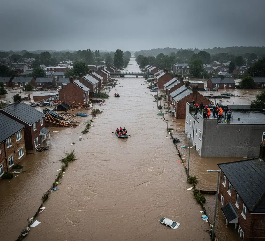
When excessive rainfall, snowmelt, or river overflow inundates low-lying areas. The accumulation of water causes floods because water accumulates faster than land or drainage systems can absorb or discharge it.
The causes of floods are:
Heavy monsoon rains
cyclones, dam breaches
Urbanization
poor drainage
encroachment on floodplains.
Flood-Prone Zones: India’s most affected regions include the Indo-Gangetic plains. The plains include the regions of Bihar, Uttar Pradesh, West Bengal and Assam. The coastal states (Odisha, Andhra Pradesh), and urban centres like Mumbai, Chennai, and Delhi are also prone to floods. Nearly 12% of India’s land area and 40 million hectares are flood-prone.
Examples: Punjab Floods in August 2025; 1400+ villages submerged heaviest in decades.
Cyclones:
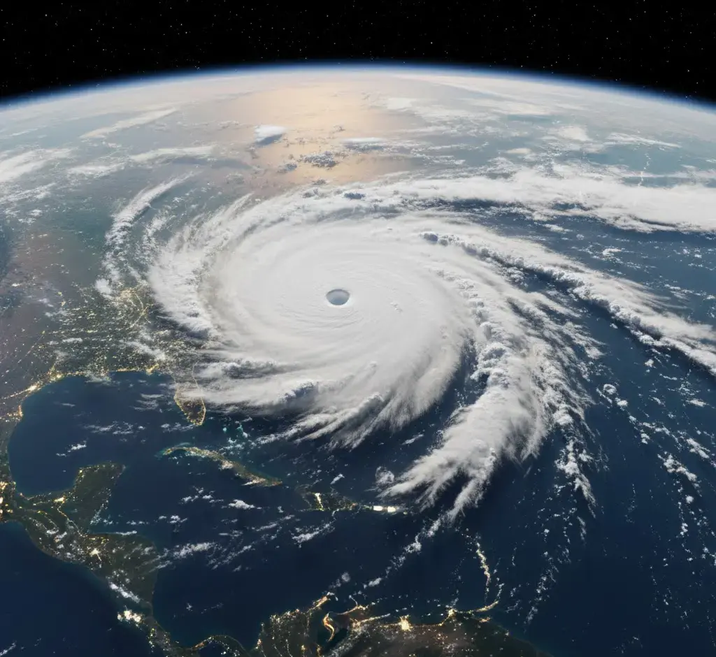
Intense low-pressure systems characterized by spiral winds and heavy rain, formed when warm ocean waters (above 27°C). They cause moisture laden air to rise, creating a vortex because of Earth’s rotation. This is also called Coriolis force.
Causes:
Triggered by high sea surface temperatures,
low vertical wind shear, and pre-existing low-pressure zones over tropical seas
They occur most commonly during pre- and post-monsoon seasons (April–May & October–December).
Cyclone-Prone Zones: About 5,700 km of India’s 11,098 km coastline is vulnerable. The specific areas towards the Bay of Bengal Side Odisha, Andhra Pradesh, West Bengal and Tamil Nadu. On the Arabian Sea Side and Gujarat, Maharashtra.
Earthquakes:
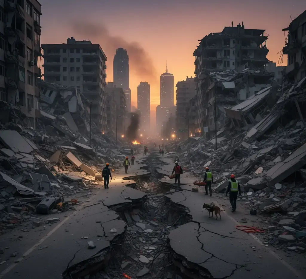
Earthquakes occur when stress release along tectonic plate boundaries or faults generates ground shaking. This builds up along stress which is released from tectonic plate boundaries and faults. India is in a convergent tectonic boundary. The Indian Plate is subducting under the Eurasian Plate. This makes the region susceptible to earthquakes.
Seismic Zones: Around 59% of India’s land area is prone to earthquakes. The active regions include the Himalayan states, Northeast India, and parts of Gujarat and Maharashtra. The affected areas fall under seismic zones IV and V.
Examples:The 2001 Gujarat earthquake (7.7 Mw) caused significant devastation. While frequent tremors continue in the Himalayan region, underscoring the region’s ongoing tectonic instability.
Landslides:
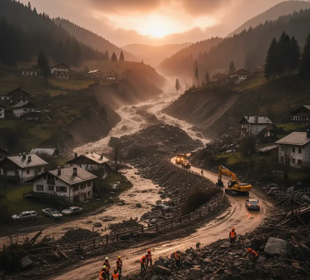
Rapid downflow of rock, soil, and debris on steep terrains which is triggered mainly by heavy rainfall, earthquakes, or snow/glacial melt.
Landslide-Prone Zones: Potential landslide zones are almost 12.6% of area in India. The areas include the northwestern part of the Himalayas, the northeastern hills, and Western Ghats.
Examples: The tragic cloudburst in Uttarakhand in June 2013, and in August 2025 in Uttarkashi (Dharali village). In 2024, the region of Manimahesh Yatra in Himachal Pradesh, witnessed landslides.
Droughts:
When there are extended stretches of insufficient rainfall coupled with a deficit in moisture, there are delays in monsoons. Such delays create water shortages which in turn affect agriculture and the livelihoods dependent on agriculture.
Causes: Some reasons are erratic monsoon tendencies, delayed commencement or premature retreat of rains. The heightened temperatures resulting in increased evaporation also add to droughts. Other human-induced causes such as the depletion of groundwater and deforestation.
Drought-Prone Zones: Around 30% of India’s geographical area is drought-prone. This includes Maharashtra (Marathwada, Vidarbha), Rajasthan, and Andhra Pradesh (Rayalaseema). Parts of Karnataka, Telangana, the Bundelkhand region (MP-UP), and portions of Odisha, Gujarat, and Jharkhand.
Heatwaves:
The Extended durations of unusually high temperatures, particularly exceeding 45°C cause Heatwaves. They are observed during the pre-monsoon period (March-June) and summer months.
Causes:Heat waves are getting more frequent and intense due to several factors.
Stagnant high-pressure systems trap heat, and reduced cloud cover allows more sunlight to reach the ground.
Cities become hotter because of the urban heat island effect.
Human driven climate change is worsening the situation.
Heatwave Prone Areas: The worst heatwaves happen in North, Central, and Western India. The states most affected are Rajasthan, Delhi-NCR, Punjab, UP, Odisha, Maharashtra, and Telangana. IMD defines a heatwave when max temperature exceeds 40°C (plains) or is 4.5°C+ above normal.
Glacial Lake Outburst Floods (GLOFs):
Water in glacial lakes can flood downstream when ice or moraine dams break. This can cause serious floods downstream.
Causes: Lake banks that are unstable and glacially fed lakes are susceptible to overdue glacial outburst floods as a result of climate change, heavy precipitation, avalanches, landslides and earthquakes.
GLOF Prone Zones: 7,500+ glacial lakes mapped in Indian Himalayas, of which 22% are showing recent area expansion (CWC 2025).
Examples: In Oct 2023: Sikkim (South Lhonak lake) GLOF caused 55 deaths.
Cloudbursts:
Very heavy rain, over 100 mm per hour, in small areas like hills or mountains can cause flash floods and landslides.
Causes: It is caused by elevation induced (Orographic) uplift of moisture-laden winds, rapid condensation, and unstable atmosphere in mountainous terrain. It occurs especially during the monsoon.
Cloudburst Prone Zones: Himalayan states like Uttarakhand, J&K, Himachal, Ladakh, parts of NorthEastern India. About 5–7% of all rainfall related disasters in mountains are linked to cloudbursts.
Examples: In Aug 2025: Uttarkashi (Uttarakhand) multiple cloudbursts, destroying villages and causing dozens of casualties.
Forest fires:
Forest Fires are uncontrolled burning of forests and vegetation, often spreading rapidly and causing extensive ecological and economic damage.
Causes: Natural causes: lightning, extreme heat/drought, accidental or manmade causes like campfires, stubble burning. They get aggravated by prolonged dry spells, deforestation, invasive species, and climate change.
Forest Fires Prone Zones: According to the Forest Survey of India (FSI), around 36% of forests are prone to fires.
Tsunamis:
The giant sea waves caused by undersea earthquakes, volcanic activity, or landslides are called tsunamis. It can cause catastrophic flooding on the coast.
Causes: Sudden displacement of the sea floor (earthquake of >7.5 magnitude), submarine volcanic eruptions or landslides displace massive water columns, generating long-wavelength waves.
Tsunami Prone Zones: The 5,700 km of Indian coastline at some risk, highest hazard for Andaman & Nicobar Islands, eastern coast (Tamil Nadu, Pondicherry, Andhra, Odisha).
Examples: Dec 2004: Indian Ocean Tsunami 9.1 Mw quake off Sumatra causing almost 11,000 deaths in Andaman & Nicobar and east coast, colossal destruction.
Man-Made Disasters in India
Human initiated calamities refer to disasters caused by human activity, carelessness, or technological breakdowns.These disasters result from human activity rather than natural processes. They include industrial or chemical accidents, fires, accidents in transportation, collapses of structures, nuclear incidents, or large-scale environmental pollution.
These disasters result in loss of life, property, and desolation of the environment, leading to additional strain on emergency systems in India. Notable examples of these disasters include the Bhopal Gas Tragedy and other avoidable tragedies like the mining accidents, major train/road accidents and fires/leaps in urban settings. These tragedies highlight the urgent need for sound systematic safety and prevention protocols.
Industrial accidents:
Catastrophic incidents in factories or facilities involving hazardous chemicals or industrial processes, resulting in mass casualties, health hazards, and environmental damage.
Causes: Typically triggered by equipment failure, safety lapses, poor maintenance, human error, or non-compliance with regulations.
Examples: Bhopal Gas Tragedy (1984);Pesticide plant’s MIC gas leak in Bhopal, Madhya Pradesh. Over 3,800 deaths instantly, with 15,000–20,000 total estimated fatalities and lingering multi-generational health/environmental impacts.
Urban floods:
Urban floods refer to the inundation of city areas due to intense rainfall overwhelming drainage systems, often amplified by poorly planned cities and encroachment.
Causes: Key drivers include inadequate or blocked stormwater drains, encroachment on traditional water bodies and floodplains, rapid unplanned construction, and compounding effects of climate change causing more intense rain events.
Urban Flood Prone Zones: Major Indian metros like Mumbai, Chennai, Delhi, Bengaluru, Hyderabad, Kolkata, and Guwahati are highly susceptible. Over 50 Indian cities are classified as flood-prone, with about 26% of India’s urban land area at some flood risk.
Examples: Chennai (2015) saw the worst city flood in a century. Over 400 people lost their lives, $3 billion in losses, large-scale displacement, and infrastructure failure.
Biological Disaster:
Events caused by the spread of pathogens (viruses, bacteria, etc.), biological agents, or toxins, leading to widespread illness, death, or ecosystem damage; also includes bio-terrorism and laboratory accidents.
Causes: Triggers may include zoonotic spillovers, pandemic outbreaks, accidental laboratory releases, bioterror attacks, and inadequate public health response.
What are the key causes of disasters in India?
Natural drivers:
India’s position at the confluence of plates makes it quake-prone (about 59% of land lies in seismic zones).
The monsoon climate brings highly variable rainfall - excess rain causes floods, deficient rain causes droughts.
Geomorphology (the Himalayas, floodplains, peninsular plateau) also shapes exposure.
Human drivers:
Rapid development and unplanned construction (expanding cities into floodplains or hillsides) dramatically increase risk.
Deforestation and soil erosion remove natural buffers, while poorly maintained infrastructure (old dams, breached canals) can fail in disasters.
Climate change intensifies all of the above: it is producing heavier downpours, fiercer cyclones and faster glacier melt.
These changes not only make events more frequent and severe, but often create cascading disasters (for example, the 2022 heatwave in India triggered glacial lake floods and wildfires).
Add as a preferred Source on Google
Institutional & Legal Framework
The Disaster Management Act of 2005 outlines the disaster management framework for India. This Act has encouraged a shift from reactive relief to proactive disaster management.
The most important components include the establishment of disaster management authorities at all levels of the government. These authorities must create disaster management plans and disaster management funds, and the emphasis on prevention and disaster management capacity building.
Key institutions under the Act include:
NDMA (National Disaster Management Authority): This is the Apex body, chaired by the Prime Minister. NDMA looks after the national policy and planning of disaster management in India. NDMA issues guidelines and approves disaster management plans for central and state agencies.
NDRF (National Disaster Response Force): NDRF is a specialised response force under MHA. They are trained for search, rescue and relief during major disasters.
NIDM (National Institute of Disaster Management): NIDM was established under the Disaster Management Act, 2005. It is the nodal training and research institute for capacity-building, education and policy advocacy on disasters.
SDMA (State Disaster Management Authority): Headed by the Chief Minister, an SDMA frames state disaster policies, coordinates resources. The state government implements national guidelines.
DDMA (District Disaster Management Authority) : The DDMA prepares and executes local disaster plans, and coordinates on the ground response and relief.These functions are usually led by the District Collector.
Disaster Risk Reduction: Policies & Measures
To move beyond relief, India emphasizes four pillars – mitigation, preparedness, response and recovery – each with targeted measures:
Prevention & Mitigation:
Enforcing land-use zoning and strict building codes in hazard-prone areas; retrofitting critical infrastructure (schools, hospitals, bridges, dams) to withstand earthquakes/cyclones; constructing embankments and urban drainage projects.
Preparedness:
Robust early warning systems (IMD weather alerts, satellite monitoring of cyclones, river gauges, etc.) give advance notice.
NDMA’s “Aapda Mitra” program is an initiative where community and officials conduct drills and simulations.
Volunteers learn first aid and search and rescue skills to help during disasters.Such community-based preparedness ( evacuation plans, volunteer networks) significantly reduces disaster tolls.
Response & Recovery:
Specialized forces like the NDRF are pre-positioned for rapid deployment when disasters strike.
State and central agencies establish relief corridors (e.g. airlifts, rail routes) to supply food, medicine and equipment.
Post-disaster recovery includes rehabilitation schemes and insurance. Crop insurance (PMFBY), housing aid and public awareness programs help affected communities rebuild their lives and livelihoods.
Nature-based / Ecosystem Approaches:
Restoring natural barriers and buffers is increasingly adopted. For example, mangrove forests along Odisha and West Bengal coasts act as living seawalls.This natural barrier helps reduce cyclone storm surge.
Bhitarkanika’s mangroves notably spared damage during Cyclone Dana.
Protecting wetlands and floodplains, and reforesting hillsides, are also nature-based strategies to absorb floods and stabilize slopes.
Way Forward: Policy Suggestions to Mitigate the Risks of Disasters in India
Strengthen Early Warning & Data: Invest in satellite and AI systems for real-time hazard monitoring (e.g. flood forecasting, cyclone tracking) and disaster databases to improve predictions and planning.
Retrofit Critical Infrastructure: Upgrade the vulnerable buildings, bridges, dams and lifeline facilities to withstand known hazards.
Expand Nature-based Solutions: Scale up mangrove/restoration projects, urban greening and wetland conservation to mitigate floods and cyclones.
Decentralize & Build Local Capacity: Empower local governments and communities with training and resources. Expand community volunteer networks (Apda Mitras) and embed disaster managers in local councils.
Reform DRR Funding: Create a dedicated national disaster risk reduction fund to finance prevention and resilience projects.
Previous Year Questions
Q. Vulnerability is an essential element for defining disaster impacts and its threat to people. How and in what ways can vulnerability to disasters be characterized? Discuss different types of vulnerability with reference to disasters. (UPSC Mains 2019).
What is the Disaster Management Act 2005?
What are some of the biggest disasters in India?
What are the 12 notified disasters in India?
What is the Sendai Framework?
Which recent disasters in India affected a large number of people?
India’s high disaster risk from earthquakes and floods to cyclones and droughts. The high risk demands a shift from reactive relief to proactive resilience. Strengthening laws (like DMA 2005), deploying technology (early warning, data analytics), and building local capacity are as crucial as conserving natural buffers (mangroves, watersheds).
In short, an integrated “culture of prevention” is needed. Law, technology, community action and ecosystem-based measures must work together to reduce risk.


Research methodology
PadhAI's research methodology ensures every article is accurate, UPSC-ready, and beginner-friendly. We curate current affairs analysis based on UPSC exam relevance by cross-referencing The Hindu, Indian Express, and PIB. General Studies (GS) topics are drafted from NCERTs and standard books such as M. Laxmikanth, Spectrum, and GC Leong, then reviewed by subject matter experts to eliminate factual errors. Additionally, we update aspirants with verified government exam notifications alongside expert blogs suggesting the best resources, syllabus, and comprehensive Prelims and Mains strategies.


Gajendra Singh Godara is an IIT Bombay graduate and a UPSC aspirant with 4 attempts, including multiple Prelims and Mains appearances. He specializes in Polity, Modern History, International Relations, and Economy. At PadhAI, Gajendra leverages his firsthand exam experience to simplify complex concepts, creating high-efficiency study materials that help aspirants save time and stay focused.
No comments yet. Be the first to join the discussion!


