National Parks in India: Map Analysis 2026
A National Park is a strict conservation zone designated by the State or Central Government to protect wildlife and natural ecosystems. The Wildlife Protection Act of 1972 defines the legal boundaries and restrictions for these areas. Unlike Wildlife Sanctuaries, where certain rights may be allowed, National Parks forbid all private rights and industrial activities within their borders.


Analysis of the National Parks in India Map
The spatial distribution of National Parks in India reveals distinct ecological clusters. The map highlights the following patterns:
Central Concentration: Madhya Pradesh acts as the core of India's wildlife conservation, hosting the highest number of parks (11), including Kanha, Bandhavgarh, and Kuno,.
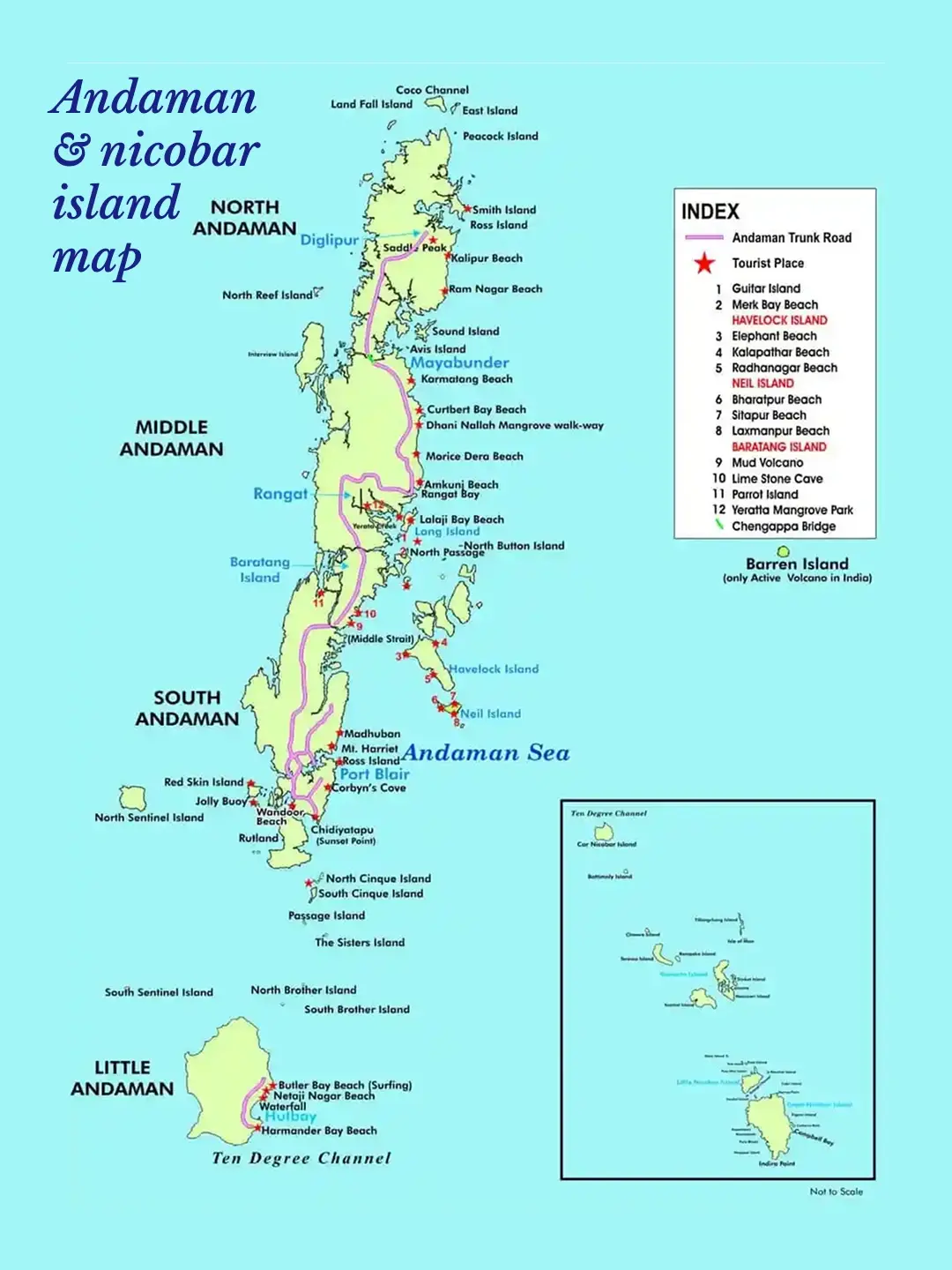
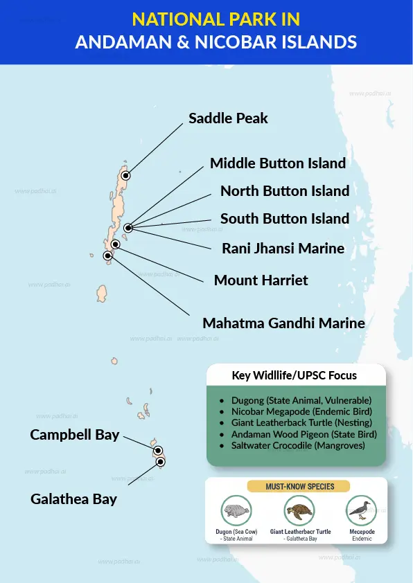
Island Biodiversity: The Andaman and Nicobar Islands contain a dense cluster of 9 parks, primarily focusing on marine and coastal ecosystems like the Mahatma Gandhi Marine National Park and the Button Islands,.
Himalayan Corridor: A continuous chain of high-altitude parks stretches across Ladakh (Hemis), Himachal Pradesh (Great Himalayan), and Uttarakhand (Nanda Devi), bordered by mountain peaks protecting snow leopards and alpine flora.
Western Ghats Line: The map shows a linear arrangement of parks along the Western Ghats in Karnataka (Bandipur, Nagarhole) and Kerala (Periyar, Eravikulam), critical for elephant and tiger corridors.
Eastern Floodplains: Assam features a riverine cluster centered around the Brahmaputra, including Kaziranga and the newly added Raimona National Park.
Andaman & Nicobar Island National Park Map
State-Wise List of National Parks in India (2026)
The table below integrates establishment years, locations, and associated river systems.
State/UT | National Park | Est. Year | Key River/Feature |
Andaman & Nicobar | Campbell Bay NP | 1992 | Galathea River nearby |
Galathea Bay NP | 1992 | Galathea River | |
Mahatma Gandhi Marine NP | 1982 | Marine Ecosystem | |
Middle Button Island NP | 1987 | Marine Biodiversity | |
Mount Harriett NP | 1987 | Tropical Forest | |
North Button Island NP | 1987 | Marine Biodiversity | |
Rani Jhansi Marine NP | 1996 | Coral Reefs | |
Saddle Peak NP | 1987 | Kalpong Dam Reservoir | |
South Button Island NP | 1987 | Smallest NP in India | |
Andhra Pradesh | Papikonda NP | 2008 | Godavari River |
Rajiv Gandhi (Rameswaram) | 2005 | Penna River | |
Sri Venkateswara NP | 1989 | Seshachalam Hills | |
Arunachal Pradesh | Mouling NP | 1986 | Siang River Valley |
Namdapha NP | 1983 | Noa-Dihing River | |
Assam | Dibru-Saikhowa NP | 1999 | Brahmaputra/Lohit |
Kaziranga NP | 1974 | Brahmaputra River | |
Manas NP | 1990 | Manas River | |
Nameri NP | 1998 | Kameng River | |
Rajiv Gandhi Orang NP | 1999 | Brahmaputra River | |
Dihing Patkai NP | 2021 | Dihing River | |
Raimona NP | 2021 | Sankosh River | |
Sikhna Jwhwlao NP | 2025 | New addition (Assam's 8th) | |
Bihar | Valmiki NP | 1989 | Gandaki River |
Chhattisgarh | Guru Ghasidas (Sanjay) NP | 1981 | Part of Sanjay-Dubri |
Indravati (Kutru) NP | 1982 | Indravati River | |
Kanger Valley NP | 1982 | Limestone Caves | |
Goa | Mollem NP | 1992 | Mandovi River Basin |
Gujarat | Vansda NP | 1979 | Ambika River nearby |
Blackbuck (Velavadar) NP | 1976 | Grassland Ecosystem | |
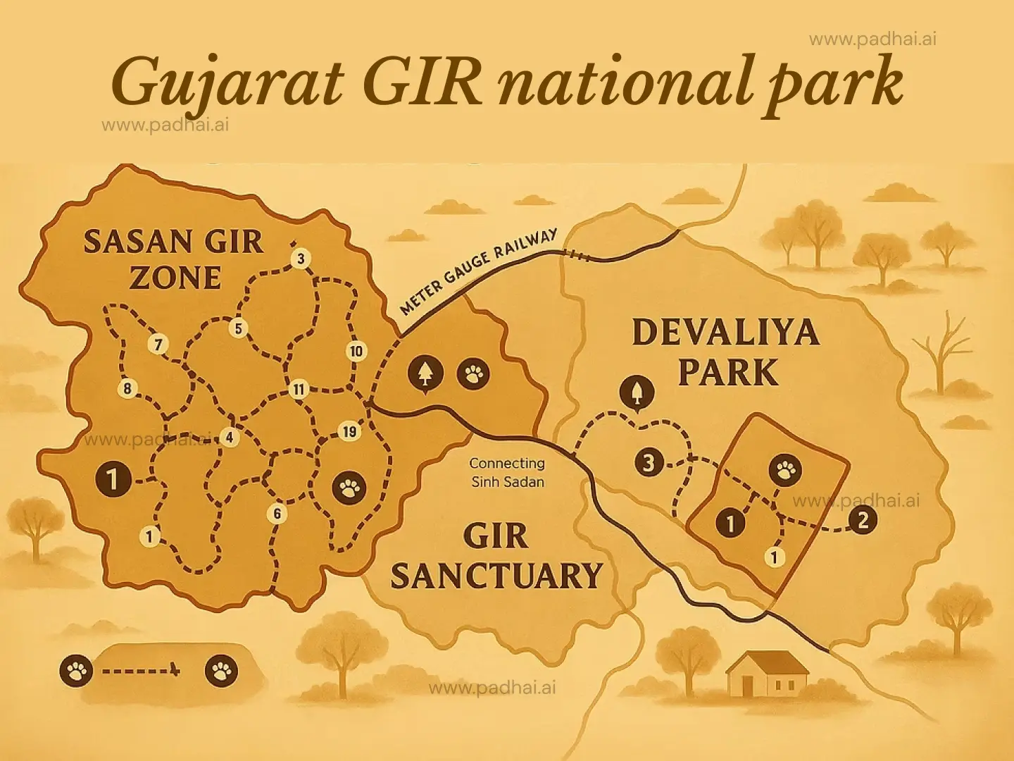
Gir National Park | 1975 | Hiran River | |
Marine (Gulf of Kachchh) NP | 1982 | Coral Reefs | |
Haryana | Kalesar NP | 2003 | Yamuna River |
Sultanpur NP | 1989 | Wetland Ecosystem | |
Himachal Pradesh | Great Himalayan NP | 1984 | Parvati/Beas River |
Inderkilla NP | 2010 | Beas River | |
Khirganga NP | 2010 | Parvati River | |
Pin Valley NP | 1987 | Cold Desert/Pin River | |
Simbalbara NP | 2010 | Terai Region | |
Jammu & Kashmir | City Forest (Salim Ali) NP | 1992 | Dal Lake |
Dachigam NP | 1981 | Marsar Lake fed | |
Kishtwar NP | 1981 | Chenab/Marusudar River | |
Kazinag NP | * | Jhelum River | |
Jharkhand | Betla NP | 1986 | North Koel River |
Karnataka | Anshi NP | 1987 | Kali River |
Bandipur NP | 1974 | Kabini River | |
Bannerghatta NP | 1974 | Granite terrain | |
Kudremukh NP | 1987 | Tunga/Bhadra Rivers | |
Nagarhole NP | 1988 | Kabini River | |
Kerala | Anamudi Shola NP | 2003 | Pambar River |
Eravikulam NP | 1978 | Pambar River | |
Mathikettan Shola NP | 2003 | Cardamom Hills | |
Pambadum Shola NP | 2003 | Smallest in Kerala | |
Periyar NP | 1982 | Periyar/Pambar Rivers | |
Silent Valley NP | 1984 | Kunthipuzha River | |
Ladakh | Hemis NP | 1981 | Indus River/Largest NP |
Madhya Pradesh | Bandhavgarh NP | 1968 | Charanganga River |
Fossil NP | 1983 | Plant Fossils | |
Pench NP | 1975 | Pench River | |
Kanha NP | 1955 | Banjar/Halon Rivers | |
Madhav NP | 1959 | Manier River | |
Panna NP | 1981 | Ken River | |
Sanjay NP | 1981 | Banas River | |
Satpura NP | 1981 | Denwa River | |
Van Vihar NP | 1979 | Bhopal City | |
Dinosaur Fossil NP | 2011 | Narmada Valley | |
Kuno NP | 2018 | Kuno River | |
Maharashtra | Chandoli NP | 2004 | Warna River |
Gugamal NP | 1975 | Melghat Tiger Reserve | |
Nawegaon NP | 1975 | Navegaon Lake | |
Pench (J. Nehru) NP | 1975 | Pench River | |
Sanjay Gandhi NP | 1983 | Urban NP (Mumbai) | |
Tadoba Andhari NP | 1955 | Andhari River | |
Manipur | Keibul-Lamjao NP | 1977 | Loktak Lake |
Shirui NP | 1982 | Shirui Hills | |
Meghalaya | Balphakram NP | 1985 | Garo Hills |
Nokrek Ridge NP | 1986 | Simsang River | |
Mizoram | Murlen NP | 1991 | Caves |
Phawngpui Blue Mtn NP | 1992 | Chhimtuipui River | |
Nagaland | Intanki NP | 1993 | Dhansiri River nearby |
Odisha | Bhitarkanika NP | 1988 | Brahmani/Baitarani |
Simlipal NP | 1980/2025 | Notified as NP in 2025 | |
Rajasthan | Mukundra Hills NP | 2006 | Chambal/Kali Rivers |
Desert NP | 1992 | Thar Desert, Primary habitat of the Critically Endangered Great Indian Bustard (State bird of Rajasthan) | |
Keoladeo Ghana NP | 1981 | Gambhir/Banganga | |
Ranthambhore NP | 1980 | Banas/Chambal Rivers | |
Sariska NP | 1992 | Aravalli Range | |
Sikkim | Khangchendzonga NP | 1977 | Teesta River |
Tamil Nadu | Guindy NP | 1976 | Urban Ecosystem |
Gulf of Mannar Marine | 1980 | Biosphere Reserve | |
Indira Gandhi (Annamalai) | 1989 | Topslip | |
Mudumalai NP | 1990 | Moyar River | |
Mukurthi NP | 1990 | ||
Telangana | Kasu Brahmananda Reddy | 1994 | Urban NP |
Mahaveer Harina Vanasthali | 1994 | Deer Park | |
Mrugavani NP | 1994 | Teak Forest | |
Tripura | Clouded Leopard NP | 2007 | Sepahijala Sanctuary |
Bison (Rajbari) NP | 2007 | Trishna Sanctuary | |
Uttar Pradesh | Dudhwa NP | 1977 | Sharda River |
Uttarakhand | Corbett NP | 1936 | Ramganga River |
Gangotri NP | 1989 | Ganga (Bhagirathi) | |
Govind National Park | 1990 | Tons River | |
Nanda Devi NP | 1982 | Rishi Ganga | |
Rajaji NP | 1983 | Ganga River | |
Valley of Flowers NP | 1982 | Pushpawati River | |
West Bengal | Buxa NP | 1992 | Raidak/Jayanti Rivers |
Gorumara NP | 1992 | Jaldhaka River | |
Jaldapara NP | 2014 | Torsa River | |
Neora Valley NP | 1986 | Neora River | |
Singalila NP | 1986 | Rammam River | |
Sunderban NP | 1984 | Delta/Mangroves |
Are there 107 or 110 National Parks in India?
The exact count of National Parks often creates confusion due to data classification methods. Government sources typically cite 107 National Parks.
However, some databases exclude the three "Button Island" parks (North, Middle, and South) in their primary count, while others include them to reach 110. Recent notifications in 2025 have added complexity:
Sikhna Jwhwlao National Park was notified by Assam in March 2025.
Similipal, long a biosphere reserve, was formally notified as a National Park by Odisha in April 2025. Therefore, while 107 is the standard figure for exams, aspirants should note the recent state-level notifications that may raise this number to 108 or higher depending on the specific update cycle of the Union Ministry.
Do Rivers Define Park Boundaries?
Yes, rivers frequently delineate the boundaries or form the lifeline of these ecosystems. The Brahmaputra floods the Kaziranga plains annually, recharging the wetlands necessary for the One-Horned Rhinoceros. The Ramganga flows through Jim Corbett, supporting its tiger population. In the south, the Periyar River defines the topography of Periyar National Park. Understanding these river-park associations is critical for solving map-based UPSC questions.
UPSC Facts: Superlatives & Updates
Oldest Park: Jim Corbett National Park (Uttarakhand), established in 1936 as Hailey National Park.
Largest Park: Hemis National Park (Ladakh), covering approximately 4,400 km², is the largest and highest altitude park,.
Smallest Park: South Button Island National Park (Andaman & Nicobar Islands) spans merely 0.03 km².
Newest Additions: While Dihing Patkai (Assam, 2021) is often cited as the newest in standard texts, the Sikhna Jwhwlao National Park (Assam) and the formal notification of Similipal (Odisha) in 2025 represent the latest administrative updates.
Floating Park: Keibul Lamjao National Park (Manipur) is the world’s only floating national park, situated on Loktak Lake.
Conclusion
National Parks are vital for maintaining India's ecological balance and preserving its genetic diversity. From the Asiatic Lions in Gir to the Snow Leopards in Hemis, these 107+ protected areas represent the country's commitment to conservation. Mastering the map locations, river associations, and recent updates allows aspirants to handle geography and environment questions in the UPSC Prelims with precision.


Gajendra Singh Godara is an IIT Bombay graduate and a UPSC aspirant with 4 attempts, including multiple Prelims and Mains appearances. He specializes in Polity, Modern History, International Relations, and Economy. At PadhAI, Gajendra leverages his firsthand exam experience to simplify complex concepts, creating high-efficiency study materials that help aspirants save time and stay focused.
Suggested Maps