Top 10 Longest Rivers in India: Length, Origin, Classification
India’s longest rivers shape its geography, economy, and civilization. This blog covers the top 10 longest rivers in India, detailing their length, origin, drainage basin, and whether they are Himalayan or Peninsular rivers

Gajendra Singh Godara
12
mins read

Rivers have sustained Indian civilization for millennia, from the Indus Valley to the Gangetic plains. India’s vast river network – with mighty Himalayan rivers and seasonal peninsular streams – underpins agriculture and cities, and holds deep cultural-religious significance (e.g. Ganga worship, Kumbh melas).
Join our WhatsApp Community
List of Top 10 Longest Rivers in India
India’s top ten longest rivers (measured within India where relevant) can be summarized as follows:
Rank | River | Length in India (km) | Origin | States Covered (India) | Drainage |
1 | Ganga | 2,525 | Gangotri Glacier (Uttarakhand) | Uttarakhand, UP, Bihar, Jharkhand, WB | Bay of Bengal |
2 | Godavari | 1,464 | Triambakeshwar (Maharashtra) | Maharashtra, Chhattisgarh, Telangana, AP | Bay of Bengal |
3 | Krishna | 1,400 | Mahabaleshwar (MH) | Maharashtra, Karnataka, Telangana, AP | Bay of Bengal |
4 | Yamuna | 1,376 | Yamunotri Glacier (Uttarakhand) | Uttarakhand, HP, Delhi, Haryana, UP | Ganga at Prayagraj |
5 | Narmada | 1,312 | Amarkantak Plateau (MP) | MP, Maharashtra, Gujarat | Arabian Sea |
6 | Indus | 1,114 | Kailash Range (Tibet) | Ladakh | Arabian Sea |
7 | Brahmaputra | 916 | Angsi Glacier (Tibet) | Arunachal Pradesh, Assam | Bay of Bengal |
8 | Mahanadi | 890 | Sihawa Hills (Chhattisgarh) | Chhattisgarh, Odisha | Bay of Bengal |
9 | Kaveri | 800 | Brahmagiri Range (Karnataka) | Karnataka, Tamil Nadu | Bay of Bengal |
10 | Tapti (Tapi) | 724 | Multai, Satpura Range (MP) | MP, Maharashtra, Gujarat | Arabian Sea |
Ganga River – The Longest River of India
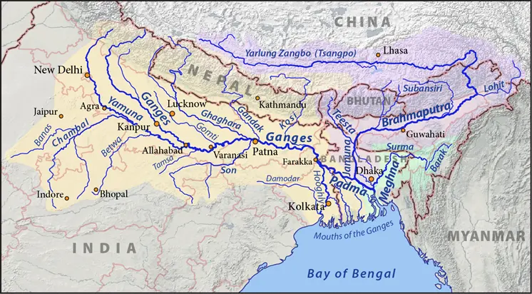
Length and course: The Ganga flows about 2,525 km within India, from the Himalayas through the fertile Gangetic Plain to the Bay of Bengal, supporting dense populations, farming, navigation, and cities along its banks.
Origin: It rises from the Gangotri Glacier in Uttarakhand; the two main headstreams, Bhagirathi and Alaknanda, meet at Devprayag to form the Ganga, which then descends through Rishikesh and Haridwar into the plains.
Tributaries:
Right-bank: Yamuna (largest), Son, Tamsa (Tons) are the major right bank tributaries.
Left-bank: Ramganga, Gomti, Ghaghara (Karnali), Sharda (Mahakali/Sarda), Gandak, Burhi Gandak, Kosi, Mahananda.
Cultural Role: Revered and declared India’s National River, Ganga river anchors major pilgrimage sitesL like Haridwar, Prayagraj (Triveni Sangam), Varanasi and shapes festivals, sacred ghats, and age-old cultural practices along its banks.
Add as a preferred Source on Google
Godavari River
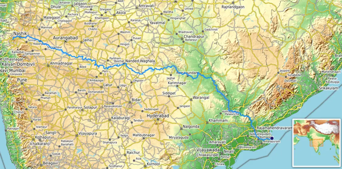
Length & Status: About 1,465 km, Godavari River is 2nd largest river in India in peninsular regions and has the largest basin among peninsular rivers.
Basin Shape & Boundaries: The basin is roughly triangular, bounded by Satmala Hills, Ajanta Range, Mahadeo Hills (north), Eastern Ghats (south & east), Western Ghats (west).
Tributaries:
Left bank: Major tributaries include Purna, Pranhita (with Penganga, Wardha, Wainganga forming sub-basin), Indravati, Sabari etc.
Right bank: Major tributaries include Pravara, Manjira, Manair, Nsardi, Sindphana etc
Major Projects & Water Management:
Polavaram Irrigation Project: multipurpose (irrigation, hydropower, water supply), large reservoir capacity. It has been accorded National Project status.
Kaleshwaram Lift Irrigation Project: one of world’s largest multi-stage lift irrigation schemes; draws water upstream (near Pranhita-Godavari confluence); energy cost & operational concerns.
Krishna River
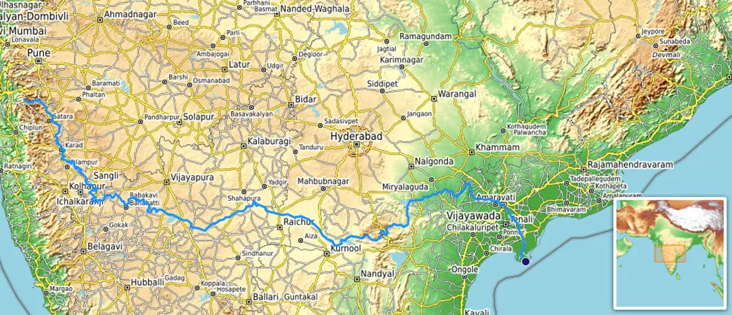
Length & Course: ~1,400 km, making it one of the top 10 longest rivers in India.
Origin: Krishna River originates at Mahabaleshwar in Western Ghats, Maharashtra; traverses Maharashtra, Karnataka, Telangana, Andhra Pradesh; empties into Bay of Bengal.
Tributaries:
Right-bank: tributaries include Tungabhadra, Koyna, Ghataprabha, Malaprabha
Left-bank: tributaries include Bhima, Musi etc.
Major Dams & Projects: Nagarjuna Sagar Dam, Srisailam Dam, Almatti Dam, Tungabhadra Dam, Prakasam Barrage, and recently Vykuntapuram Barrage (for storing flood water & irrigation).
Economic & Agricultural Role: Supports crops like paddy, sugarcane etc.; delta region is fertile; irrigation infrastructure installed.
Yamuna River – Longest Tributary of Ganga
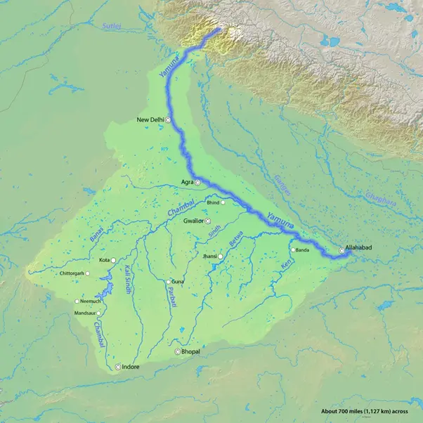
Length & Course: ~1,376 km; source at Yamunotri Glacier (Uttarakhand); flows through Uttarakhand, Himachal Pradesh, Haryana, Delhi, Uttar Pradesh before meeting the Ganga at Prayagraj.
Tributaries:
Right bank: Tributaries include Tamsa (Tons), Chambal (originates from the Janapav hills on the Malwa Plateau), Sind, Betwa , Ken, etc.
Left Bank: Tributaries include Hindon, Varuna (local), etc.
Projects / Barrages: Multiple barrages: Hathnikund, Wazirabad, Okhla, Mathura (Gokul) etc.; also several under-construction hydropower projects on Yamuna River have been carried out.
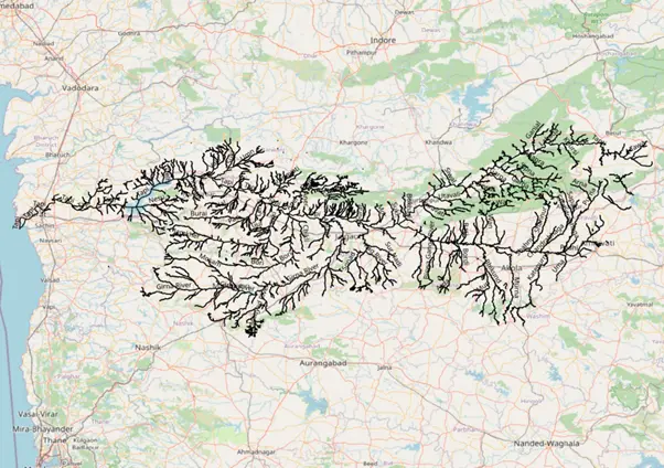
Narmada River
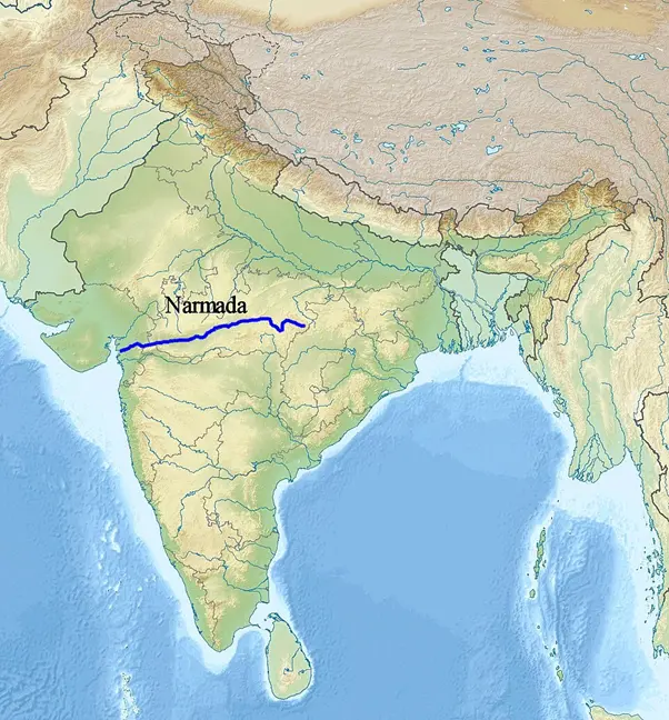
Length & Course: ~1,312 km; Narmada River originates from Amarkantak Plateau, flows west-wards between Vindhya & Satpura ranges; empties into Arabian Sea (Gulf of Khambhat).
Tributaries:
Right-bank: Major Tributaries are Hiran, Tendoni and Choral
Left-bank : Tributaries include Burhner, Banjar, Sher, and Karjan
West-flowing River Feature: One of few large peninsular rivers flowing west.
Major Projects: Sardar Sarovar Dam, Omkareshwar, Bargi etc.
Indus River
Length & Location of Indus River: Total ~3,180 km, but only ~1,114 km within India (Ladakh etc.). Originates near Lake Mansarovar in the Tibet Plateau. Flows from Tibet, through India, then into Pakistan.
Tributaries in India: Indus river has tributaries like Sutlej, Beas, Ravi, Jhelum, Chenab etc. These create the major Indus basin in India.
Treaty & International Rivers: Indus Waters Treaty (1960) – issues of rights, upstream development (glacier melt, dams in Tibet/Ladakh).
To know more about the International importance of the river check our blog Indus Water Treaty
Brahmaputra River – Largest River in India by Volume
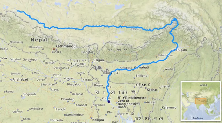
Length & Course: ~2,900 km total, ~916 km in India across Arunachal Pradesh & Assam.
Origin: From Tibetan glaciers near Mount Kailash from the Chemayungdung Glacier; Brahmaputra river flows east as the Yarlung Tsangpo before entering India; merges with Ganga/Meghna into Bay of Bengal.
Discharge & Floods: The river has very high discharge and brings heavy silt, causing major monsoon floods each year. Erosion and channel shifts have shrunk river islands like Majuli over time.
Tributaries:
Right bank: tributaries include Subansiri, Kameng, Manas, Sankosh, and Teesta.
Left bank: tributaries include Lohit, Dibang, Dhansiri, and Kapili.
Transboundary & Climate Issues: Upstream dams and projects in Tibet raise concerns about downstream flows and sediment patterns. Glacier retreat and changing monsoon patterns add uncertainty to water availability and flood risks.
Mahanadi River
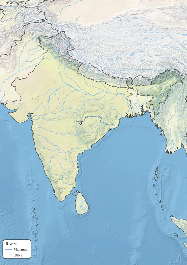
Length & Course: The Mahanadi is about 858–890 km long; it rises in the Sihawa/Pharsiya area of Chhattisgarh, crosses the Chhattisgarh Plain and Odisha, and empties into the Bay of Bengal
Major Projects: Hirakud is among India’s earliest multipurpose dams and the world’s longest earthen dam; it creates a vast reservoir (Ramsar site) enabling irrigation, flood moderation, and 359.8 MW hydropower.
Tributaries:
Major left bank tributaries include Seonath, Hasdeo, Mand, Ib
Right bank tributaries include Ong, Tel, Jonk.
Kaveri River (Cauvery)
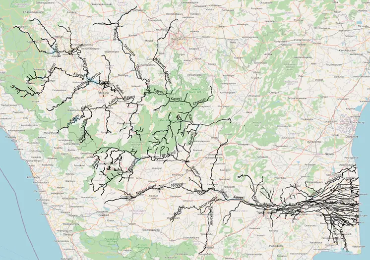
Length & Role: Kaveri River is about 800 km long; it rises at Talakaveri in the Brahmagiri range (Western Ghats, Karnataka), flows through Karnataka and Tamil Nadu, and forms a fertile delta before entering the Bay of Bengal.
Tributaries:
Left bank: Hemavati, Shimsha, Arkavathi, Suvarnavathi, Lakshmana Tirtha, Harangi.
Right bank: Kabini, Bhavani, Noyyal, Amaravati.
These tributaries sustain flows and agriculture from the plateau to the delta.
Major projects: Key infrastructures include Krishnaraja Sagar (KRS), Mettur (Stanley) Dam, and numerous anicuts/canals that support irrigation, drinking water, and hydropower across the basin.
Dispute & Judicial Orders: The interstate Cauvery water dispute (mainly Karnataka–Tamil Nadu, with Kerala and Puducherry as parties) has led to tribunal awards and Supreme Court directions on allocations, especially during lean seasons.
Tapti River (Tapi)
Length & Course: The Tapti is about 724 km long; it rises near Multai in the Satpura (Madhya Pradesh), flows through Maharashtra and Gujarat, and empties into the Arabian Sea via the Gulf of Khambhat.
West-Flowing Feature: Like Narmada, one of the west-flowing peninsular rivers; used often in contrast questions (east vs west flowing rivers).
Major tributaries:
Left bank: Purna, Girna, Bori, Panjhra, Waghur.
Right bank: Aner, Arunavati, Gomai.
Projects & Management: Key infrastructures include Ukai (Vallabh Sagar) Dam in Gujarat and several medium dams/anicuts in Maharashtra for irrigation, flood moderation, and power.
Environmental concerns: Strong monsoon dependence causes seasonal flow swings; siltation and lower discharge than larger basins affect flood control, water reliability, and estuarine health near Surat.
Importance of Major Indian Rivers
Irrigation & Agriculture: Over one-third of India’s farmland relies on river irrigation. For instance, the Ganga plain, Godavari-Krishna basins, and Punjab (through Sutlej/Beas) are India’s granaries. Large canal networks (e.g. Ganga Canal, Indira Gandhi Canal) distribute river water across states.
Hydroelectricity & Industry: Dams on Himalayan rivers (Bhakra-Nangal on Sutlej, Tehri on Bhagirathi, Farakka on Ganga) and Peninsular rivers (Srisailam on Krishna, Hirakud on Mahanadi, Sardar Sarovar on Narmada) generate electricity for millions. Rivers also supply water for industries (steel, thermal plants) near their banks.
Drinking Water & Biodiversity: Major cities and villages draw drinking water from rivers or their reservoirs. River basins harbour rich biodiversity: e.g. the Sundarbans delta (Ganga-Brahmaputra) is a UNESCO biosphere with Bengal tigers and mangroves; Kaziranga (on the Brahmaputra) hosts the Indian rhinoceros; Nanda Devi and Gangotri glaciers feed alpine ecosystems upstream.
Cultural & Religious Value: Rivers like Ganga, Yamuna, Godavari and Kaveri hold deep religious significance. The Ganga is holiest in Hinduism, personified as a mother-goddess. Pilgrimage sites and festivals abound on riverbanks (Varanasi on Ganga, Prayagraj Sangam, Nashik on Godavari during Kumbh). Even tribal communities revere rivers as deities or life-givers.
Transportation & Economy: Historically, rivers were trade routes (e.g. Brahmaputra in Assam, Ganga in UP). While inland navigation declined, recent interlinking projects aim to revive riverine transport. Rivers also replenish ground water and support fisheries and riverine parks.
In line with COP 29 goals to accelerate the global energy transition, India’s major rivers like the Ganga and Krishna play a pivotal role in achieving net-zero targets through sustainable hydropower projects.
UPSC Previous Year Questions
Q. With reference to the Himalayan rivers joining the Ganga downstream of Prayagraj from West to East, which one of the following sequences is correct? [2024]
a) Ghaghara — Gomati — Gandak — Kosi
b) Gomati — Ghaghara — Gandak — Kosi
c) Ghaghara — Gomati — Kosi — Gandak
d) Gomati — Ghaghara — Kosi — Gandak
Answer: (b)
Q. Consider the following information: [2024]
Waterfall | Region | River |
|---|---|---|
Dhuandhar | Malwa | Narmada |
Hundru | Chota Nagpur | Subarnarekha |
Gersoppa | Western Ghats | Netravati |
In how many of the above rows is the given information correctly matched?
a) Only one
b) Only two
c) All three
d) None
Answer: (a)
Q. Consider the following statements: [2023]
Jhelum River passes through Wular Lake
Krishna River directly feeds Kolleru Lake
Meandering of Gandak River formed Kanwar Lake
How many of the statements given above are correct?
a) Only one
b) Only two
c) All three
d) None
Answer: (a)
Other Related Links :
Indian Monsoons: Patterns, Types, Impacts, Regional Disparities & UPSC Relevance
Landslides in India, Types, Causes, Effects, Prevention & Mitigation
Samudrayaan Mission: India’s Deep Sea Exploration, Matsya-6000
Tsunami UPSC, Meaning, Characteristics, Causes, Impacts & Mitigation Measures
National Deep Water Exploration Mission, Objectives & Significance
Which is the longest river in India?
Which is the largest river of India by volume?
What is the 2nd largest river in India?
How many major rivers are there in India?
Which are the top 10 longest rivers in India for UPSC?
India’s river network is integral to its identity and prosperity. The Ganga reigns as the longest river (in India) and cultural icon, while the Brahmaputra dominates by volume. Together with other major rivers – the Godavari, Krishna, Yamuna, Narmada, and co. – they irrigate crops, generate power, sustain forests and wildlife, and bear deep spiritual meaning.
Questions on India’s longest/ largest rivers, their tributaries and basins are staples in UPSC prelims and mains. Ultimately, rivers are more than physical features; they are lifelines that have shaped India’s civilization and will determine how well we meet future sustainability challenges. Thorough familiarity with these rivers and their courses, tributaries, and significance is essential for any UPSC aspirant aiming to master Indian geography and environment.


Research methodology
PadhAI's research methodology ensures every article is accurate, UPSC-ready, and beginner-friendly. We curate current affairs analysis based on UPSC exam relevance by cross-referencing The Hindu, Indian Express, and PIB. General Studies (GS) topics are drafted from NCERTs and standard books such as M. Laxmikanth, Spectrum, and GC Leong, then reviewed by subject matter experts to eliminate factual errors. Additionally, we update aspirants with verified government exam notifications alongside expert blogs suggesting the best resources, syllabus, and comprehensive Prelims and Mains strategies.


Gajendra Singh Godara is an IIT Bombay graduate and a UPSC aspirant with 4 attempts, including multiple Prelims and Mains appearances. He specializes in Polity, Modern History, International Relations, and Economy. At PadhAI, Gajendra leverages his firsthand exam experience to simplify complex concepts, creating high-efficiency study materials that help aspirants save time and stay focused.
No comments yet. Be the first to join the discussion!


