Indus Valley Civilization Map | PDF & Download Image
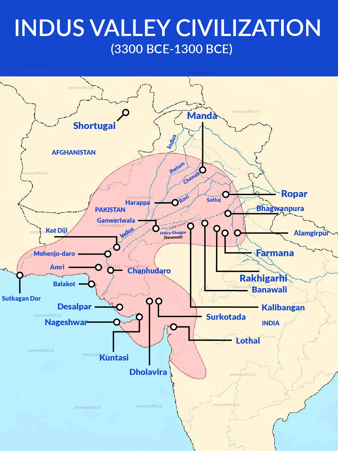
The Indus Valley Civilization (IVC) was a Bronze Age society that flourished between 3300 BCE and 1300 BCE in the northwestern Indian subcontinent. It encompassed approximately 1,299,600 square kilometers, an area larger than ancient Egypt and Mesopotamia combined.

Indus Valley Civilization Sites Map
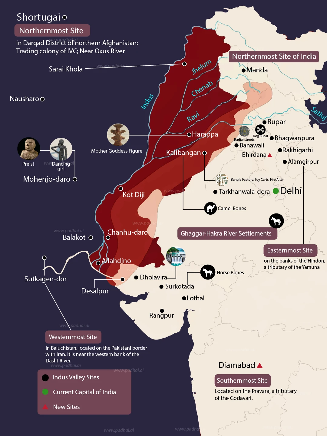
The civilization's map forms a "diamond" shape anchored by four extreme boundaries:
Northernmost: Manda (Jammu & Kashmir) and the trading outpost Shortugai (Afghanistan).
Southernmost: Daimabad (Maharashtra) on the Pravara River.
Westernmost: Sutkagan Dor (Balochistan) near the Iranian border.
Easternmost: Alamgirpur (Uttar Pradesh) on the Hindon River.
Hydrological Arteries Settlement density correlates strongly with river systems. The civilization thrived along two main corridors: the Indus River system (Indus, Ravi, Chenab) and the Ghaggar-Hakra system (identified by some as the Saraswati). Major cities like Mohenjo-daro and Chanhudaro developed on the Indus banks, while Kalibangan and Banawali arose along the Ghaggar.
Indus Valley Civilization Site Functions
The map reveals distinct functional zones based on geography and available resources.
The Coastal Belt (Maritime Trade) Sites along the coastline indicate a robust maritime trade network connecting to Mesopotamia and the Persian Gulf.
Lothal (Gujarat): Features the world’s earliest known tidal dockyard connected to the Bhogavo River.
Sutkagan Dor and Balakot: Functioned as coastal outposts facilitating sea-borne commerce.
Dholavira (Gujarat): Located in the Rann of Kutch, this site functioned as a "water fort" (Jala Durga) with sophisticated reservoirs.
The Resource Hinterlands Inland sites often specialized in sourcing raw materials.
Shortugai (Afghanistan): Provided access to lapis lazuli mines.
Khetri Region (Rajasthan): Nearby sites like Kalibangan likely sourced copper from the Aravalli Range.
Is the map of the Indus Valley Civilization static?
No. The geographical footprint of the civilization shifted over time.
Early Harappan (3300–2600 BCE): Settlements originated in the Baluchistan hills and slowly moved into the river plains.
Mature Harappan (2600–1900 BCE): This phase saw peak urbanization with five major cities: Harappa, Mohenjo-daro, Dholavira, Ganweriwala, and Rakhigarhi.
Late Harappan (1900–1300 BCE): As the Ghaggar-Hakra system dried up and monsoons weakened, the population dispersed eastward towards the Gangetic plains.
Final Observations
The map of the Indus Valley Civilization is a document of human adaptation. From the flood-supported farming of the Indus plains to the water harvesting systems of arid Dholavira, the geography dictated the lifestyle. For UPSC aspirants, memorizing the location of these sites relative to rivers and modern state borders is essential for solving map-based Prelims questions.


Gajendra Singh Godara is an IIT Bombay graduate and a UPSC aspirant with 4 attempts, including multiple Prelims and Mains appearances. He specializes in Polity, Modern History, International Relations, and Economy. At PadhAI, Gajendra leverages his firsthand exam experience to simplify complex concepts, creating high-efficiency study materials that help aspirants save time and stay focused.
Suggested Maps