Brahmaputra River Map | PDF & Image Download

The Brahmaputra River originates at the Chemayungdung Glacier and flows 2,900 kilometers across Tibet, India, and Bangladesh. This transboundary system drains 580,000 square kilometers and supports the Assam Valley's agriculture before forming a massive delta in the Bay of Bengal.

 Map showing the Brahmaputra river course from Chemayungdung Glacier through Arunachal Pradesh and Assam to the Bay of Bengal.
 Map showing the Brahmaputra river course from Chemayungdung Glacier through Arunachal Pradesh and Assam to the Bay of Bengal.
 Map showing the Brahmaputra river course from Chemayungdung Glacier through Arunachal Pradesh and Assam to the Bay of Bengal.
 Map showing the Brahmaputra river course from Chemayungdung Glacier through Arunachal Pradesh and Assam to the Bay of Bengal.

Download Map

Download Map

Brahmaputra River Course Trajectory and Regional Nomenclature

Flow of Brahmaputra river map

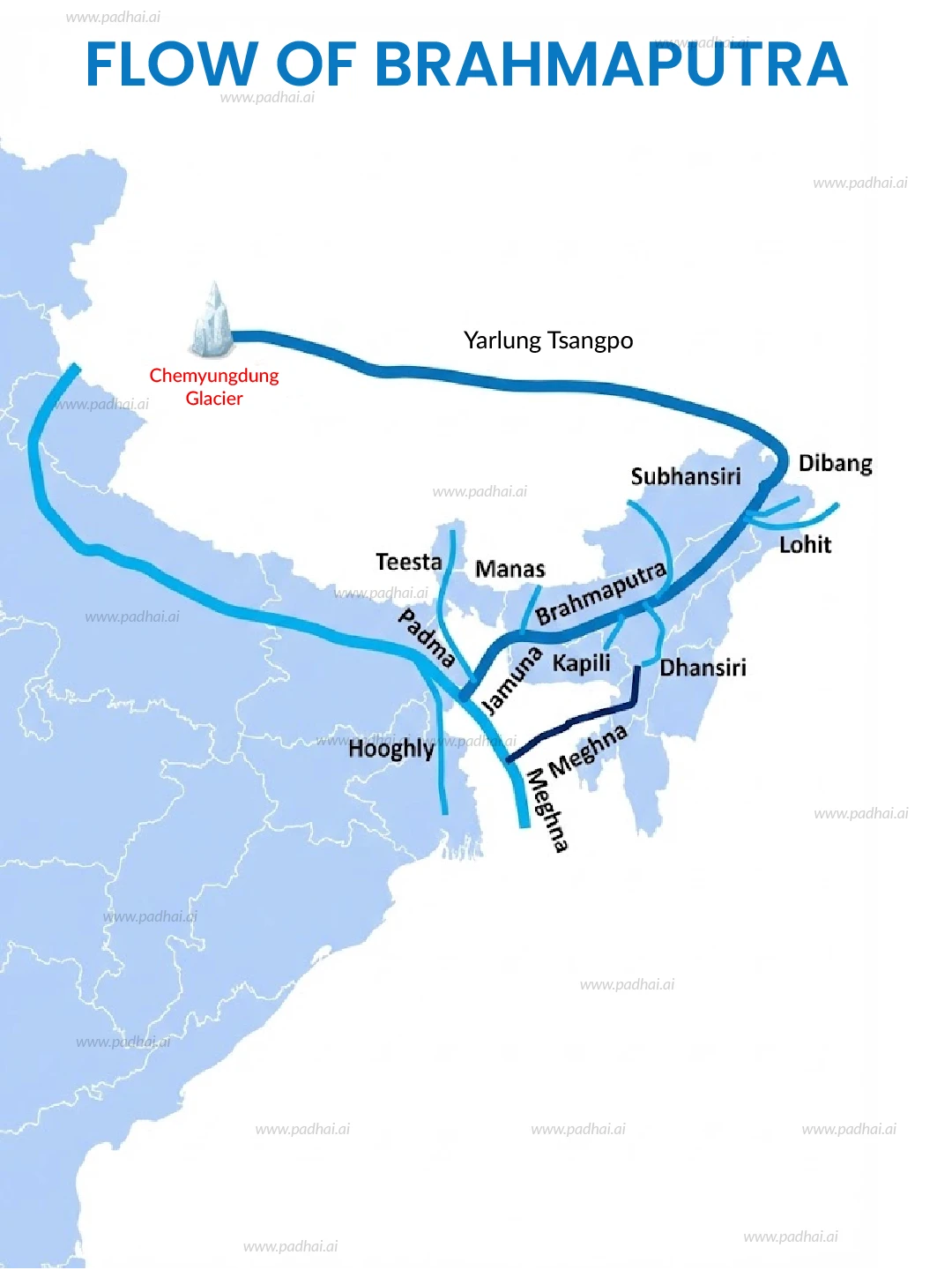
The river exhibits distinct physical characteristics and adopts different names as it traverses diverse topographic zones.

  • Tibet (Source): The river rises from the Chemayungdung Glacier near Mount Kailash at an altitude of 5,300 meters. Local populations refer to this section as the Yarlung Tsangpo, which flows eastward for 1,600 kilometers across the Tibetan Plateau.

  • India (Entry): The river enters India through Arunachal Pradesh after negotiating the Great Bend at the Namcha Barwa Gorge. Here, the river takes the name Siang or Dihang and flows for 230 kilometers to Pasighat.

  • Assam (Expansion): Two major tributaries, the Dibang and the Lohit, join the Siang near Pasighat to form the Brahmaputra proper. The channel expands significantly in the Assam plains, measuring up to 10 kilometers wide in places.

  • Bangladesh (Exit): The river turns south into Bangladesh, merging with the Ganga (Padma) to become the Jamuna, finally emptying into the Bay of Bengal.

Conclusion

The Brahmaputra River Map defines a high-volume, sediment-rich hydrological system that drains the Tibetan Plateau and the Eastern Himalayas. It flows 2,900 kilometers, supports a catchment of 580,000 square kilometers, and provides the foundation for the economy and ecology of Northeast India. The river sustains critical biodiversity in Kaziranga and Manas while simultaneously posing risks through annual flooding and erosion.

a close up of a cell phone with a blurry background

About Author

Gajendra Singh Godara

Growth | FTE| Resident at SigIQ

Gajendra Singh Godara brings authentic UPSC preparation insights from his four-attempt journey, having successfully cleared Prelims and written Mains multiple times. His deep expertise spans Polity, Modern History, International Relations, and Economy. At PadhAI, Gajendra transforms his extensive exam experience into accessible content that simplifies complex concepts for aspirants at every preparation stage. His firsthand understanding of UPSC's demands enables him to create targeted materials that save time while maximizing learning efficiency for current affairs, general studies, and optional subjects.

Suggested Maps

Equator Map Passing Through Countries

Equator Map Passes Through Countries | PDF & Image Download

Equator Map Passing Through Countries

Equator Map Passes Through Countries | PDF & Image Download

Major Rivers of World Map

Major Rivers of World Map: PDF & Image Download

Major Rivers of World Map

Major Rivers of World Map: PDF & Image Download

Major Mountain Ranges of World

Major Mountain Ranges of World: PDF & Image Download

Major Mountain Ranges of World

Major Mountain Ranges of World: PDF & Image Download

UNESCO World Heritage Sites in India Map

UNESCO World Heritage Sites in India Map: PDF & Image Download

UNESCO World Heritage Sites in India Map

UNESCO World Heritage Sites in India Map: PDF & Image Download

Krishna River Map

Krishna River Map: PDF & Image Download

Krishna River Map

Krishna River Map: PDF & Image Download

Equator Map Passing Through Countries

Equator Map Passes Through Countries | PDF & Image Download

Major Rivers of World Map

Major Rivers of World Map: PDF & Image Download

Major Mountain Ranges of World

Major Mountain Ranges of World: PDF & Image Download

UNESCO World Heritage Sites in India Map

UNESCO World Heritage Sites in India Map: PDF & Image Download

Krishna River Map

Krishna River Map: PDF & Image Download

Cauvery River Map

Cauvery River Map: PDF & Image Download

Equator Map Passing Through Countries

Equator Map Passes Through Countries | PDF & Image Download

Major Rivers of World Map

Major Rivers of World Map: PDF & Image Download

Major Mountain Ranges of World

Major Mountain Ranges of World: PDF & Image Download

UNESCO World Heritage Sites in India Map

UNESCO World Heritage Sites in India Map: PDF & Image Download

Download PadhAI App

Don't get left behind in your preparation

Download PadhAI App

Don't get left behind in your preparation

Download PadhAI App

Don't get left behind in your preparation

Download PadhAI App

Don't get left behind in your preparation

Current Affairs

UPSC Resources

UPSC updates

General studies

UPSC Preparation

Get FREE 1-Year PadhAI Premium Access (Worth ₹3,500)

Get FREE 1-Year PadhAI Premium Access (Worth ₹3,500)