

Downlaod Uttarakhand Map: Districts, Rivers, National Parks & Tiger Reserves

PadhAI Editorial Team
Last updated

Download Map
Download Map

PadhAI Editorial Team
Content & Research | PadhAI by SigIQ.ai
The PadhAI Editorial Team writes and reviews everything you read on padhai.ai: daily and monthly current affairs, static subject notes, magazines, exam notifications, previous year paper analysis and answer keys. The desk is led by Gajendra Singh Godara and Kartikey Mishra, with Naman and Vishwajeet writing across the syllabus. Team coverage includes Geography, Environment and Ecology, Science and Technology, Ancient and Medieval History, Art and Culture, Governance and Social Justice, Ethics and CSAT. Polity, Modern History, International Relations and Economy are covered by Gajendra. Every article is checked against official sources such as UPSC notifications, PIB, ministry releases and the Economic Survey, and is updated whenever the source changes.
PadhAI Editorial Team
Content & Research | PadhAI by SigIQ.ai
The PadhAI Editorial Team writes and reviews everything you read on padhai.ai: daily and monthly current affairs, static subject notes, magazines, exam notifications, previous year paper analysis and answer keys. The desk is led by Gajendra Singh Godara and Kartikey Mishra, with Naman and Vishwajeet writing across the syllabus. Team coverage includes Geography, Environment and Ecology, Science and Technology, Ancient and Medieval History, Art and Culture, Governance and Social Justice, Ethics and CSAT. Polity, Modern History, International Relations and Economy are covered by Gajendra. Every article is checked against official sources such as UPSC notifications, PIB, ministry releases and the Economic Survey, and is updated whenever the source changes.
Suggested Maps
Downlaod Uttarakhand Map: Districts, Rivers, National Parks & Tiger Reserves
Downlaod Uttarakhand Map: Districts, Rivers, National Parks & Tiger Reserves

Middle East Map: Countries, Regions, Major Cities & Rivers
Middle East Map: Countries, Regions, Major Cities & Rivers

Haryana Map: Districts, Rivers, National Parks & Ramsar Sites
Haryana Map: Districts, Rivers, National Parks & Ramsar Sites

Aravalli Range Map: Location, Extent & Peaks
Aravalli Range Map: Location, Extent & Peaks
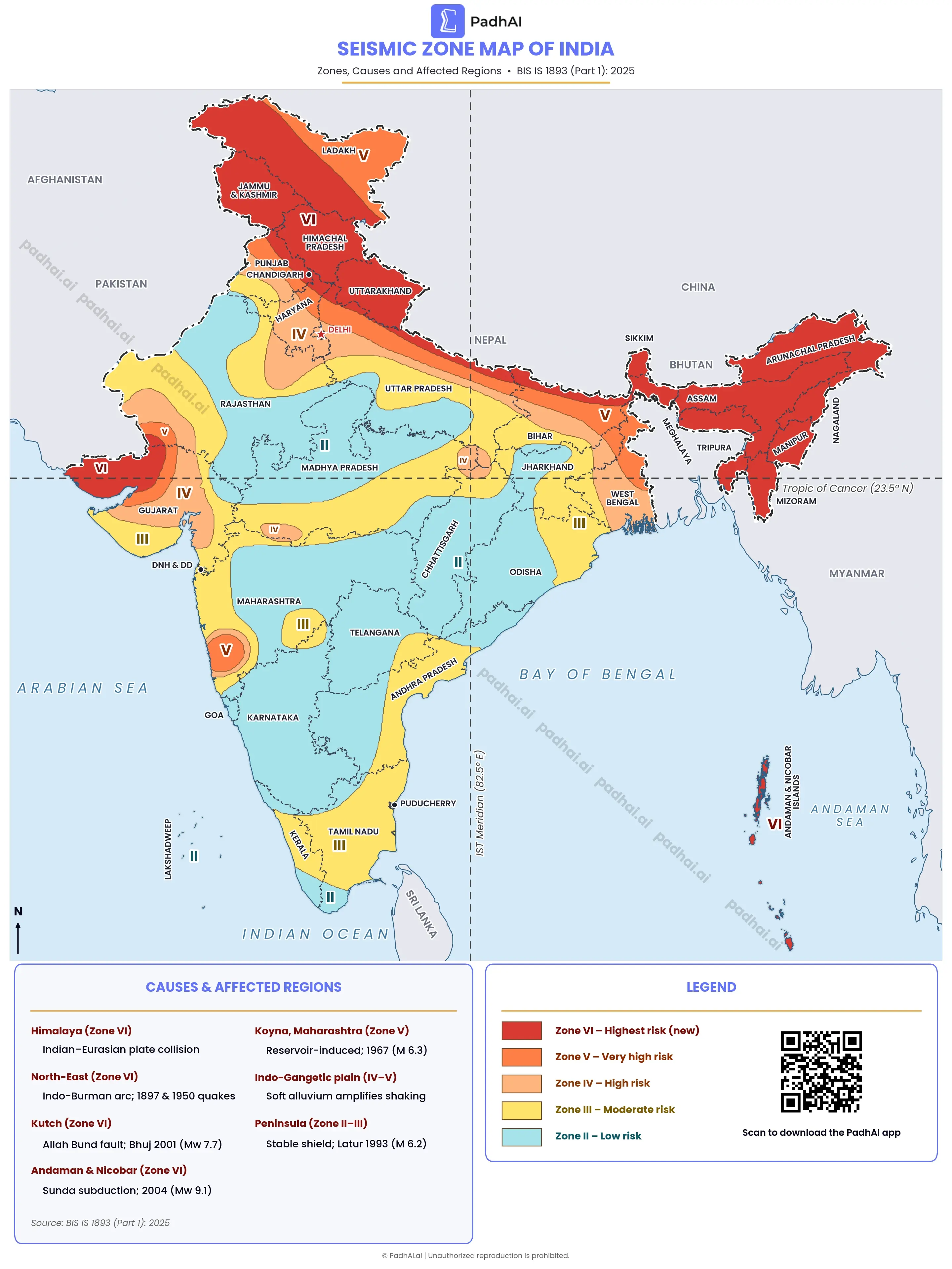
Seismic Zone Map of India: Earthquake Risk Zones
Seismic Zone Map of India: Earthquake Risk Zones
Downlaod Uttarakhand Map: Districts, Rivers, National Parks & Tiger Reserves
Middle East Map: Countries, Regions, Major Cities & Rivers
Haryana Map: Districts, Rivers, National Parks & Ramsar Sites
Aravalli Range Map: Location, Extent & Peaks
Seismic Zone Map of India: Earthquake Risk Zones

Download Deccan Plateau Map: Sub-plateaus, Hill Ranges & Rivers










PadhAI is a product of SigIQ AI
Support
Address
02-206, Sigiq.ai, Vi-John Tower, 393, Phase III, Udyog Vihar, Sector 20, Gurugram, Haryana 122016
© 2025-2026, All Rights Reserved
PadhAI is a product of SigIQ AI
Support
Address
02-206, Sigiq.ai, Vi-John Tower, 393, Phase III, Udyog Vihar, Sector 20, Gurugram, Haryana 122016
© 2025-2026, All Rights Reserved
PadhAI is a product of SigIQ AI
Support
Address
02-206, Sigiq.ai, Vi-John Tower, 393, Phase III, Udyog Vihar, Sector 20, Gurugram, Haryana 122016
© 2025-2026, All Rights Reserved