Nepal Flash Floods 2026: Causes, GLOF & India Impact
Nepal flash floods 2026 show how a sudden collapse of ice and rock in the Himalayas can cause a fast-moving flood. For UPSC, the main areas to revise are flash floods, GLOFs, Himalayan vulnerability, the Gandak river system and disaster preparedness.
Last updated
8
mins read
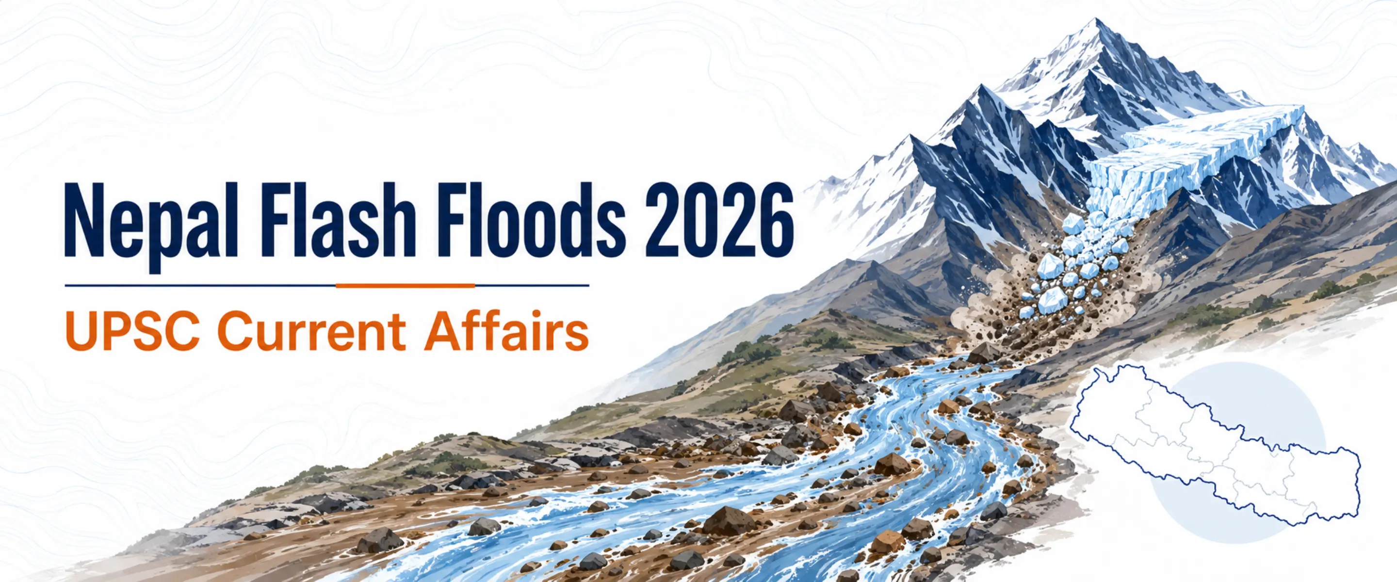
A major flash flood hit Nepal's Rasuwa district near the Nepal-China border on 26 August 2026. A sudden rush of water, mud and rocks moved through the Bhote Koshi and Trishuli river system, damaging settlements, roads, bridges and hydropower facilities.
Scientists at the International Centre for Integrated Mountain Development (ICIMOD) are examining whether a large mass of ice and rock fell into Lende Khola, a tributary of the Bhote Koshi, and triggered the flood. The final cause has not yet been confirmed.
Rasuwa lies in Nepal's central Himalayan region, close to Tibet. Rivers in this area flow through steep and narrow valleys, so a sudden increase in water can travel downstream very quickly.
The river connection is important for UPSC geography:
Lende Khola -> Bhote Koshi -> Trishuli -> Narayani -> Gandak -> India
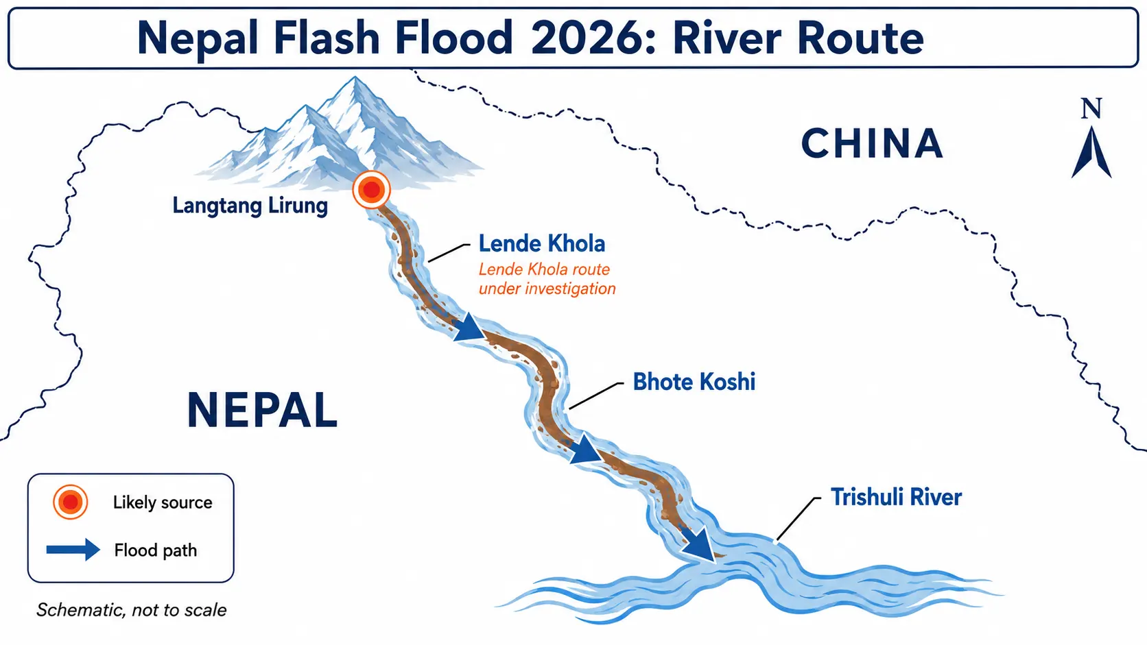
The Narayani enters India as the Gandak and flows through parts of Uttar Pradesh and Bihar. This is why a flood that begins high in Nepal can also require monitoring in India.
Join our WhatsApp Community


Point | What to remember |
Date | 26 August 2026 |
Main affected area | Rasuwa district near the Nepal-China border |
River system | Lende Khola -> Bhote Koshi -> Trishuli -> Narayani -> Gandak |
Suspected trigger | Collapse of ice and rock; final cause is still under investigation |
River rise | About 9 m at Galchchi and 7 m at Malekhu in around 30 minutes |
India connection | The river system enters India through the Gandak basin |
A flash flood is a flood that develops very quickly, usually within minutes or a few hours. Because the water rises so fast, people often get little time to move to safer ground.
Flash floods can be caused by very heavy rainfall, a cloudburst, the sudden failure of a dam or natural blockage, rapid snow or ice melt, or a Glacial Lake Outburst Flood.
Mountain areas face greater danger because steep slopes increase the speed of flowing water.
The flood may also carry mud, trees, rocks and boulders, which can destroy roads, bridges and buildings.
Add as a preferred Source on Google
A Glacial Lake Outburst Flood (GLOF) happens when water stored in a lake near a glacier is suddenly released.
As a glacier melts or retreats, water can collect near it. In some places, the lake is held back only by loose rock, soil or ice.
If this natural barrier breaks, a large amount of water can rush down the valley in a short time.
A GLOF may be triggered by an avalanche or landslide falling into the lake, an earthquake, heavy rainfall, rapid melting, or weakening of the natural barrier.
Flash Flood vs GLOF
The two terms are related but they do not mean the same thing.
Flash flood describes a flood that develops very quickly.
GLOF describes one particular cause of a sudden flood: the release of water from a glacial lake.
A GLOF can create a flash flood, but many flash floods have nothing to do with a glacial lake.
The August 2026 Nepal disaster should not be called a confirmed GLOF at this stage.
India's early Central Water Commission alert referred to suspected flash flood/GLOF activity, while ICIMOD later said a collapse of ice and rock was the suspected trigger and that the exact cause was still being investigated.
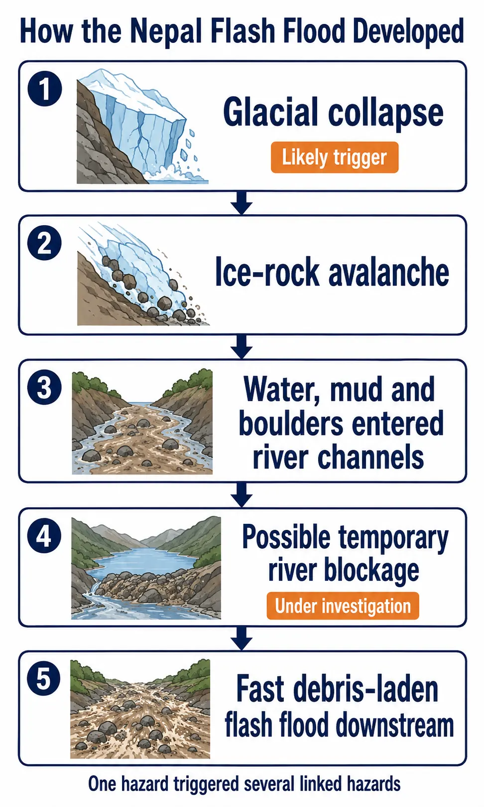
The suspected sequence is:
Ice and rock fall from a high slope -> material enters the river valley -> river flow is disturbed or temporarily blocked -> water and debris rush downstream -> flash flood
ICIMOD's preliminary assessment suggests that a large mass of ice and rock may have entered Lende Khola. Scientists are also examining whether the fallen material briefly blocked the river.
A temporary blockage can hold back water and then release it suddenly if the natural dam breaks.
Early reports also discussed an earthquake. However, a large avalanche or landslide can itself produce strong ground vibrations.
Aspirants should therefore avoid writing that an earthquake or a GLOF definitely caused the event until the final scientific assessment is available.
1. Young and unstable mountains
The Himalayas are young fold mountains formed by the continuing collision of the Indian and Eurasian plates. Many slopes contain fractured or loose rock, which makes landslides and slope failures common.
2. Steep slopes and narrow valleys
Himalayan rivers descend sharply from high mountains. When a large amount of water suddenly enters a narrow valley, it can move at high speed and carry heavy debris with it.
3. Intense monsoon rainfall
Heavy rain can raise river levels, weaken slopes and trigger landslides. A landslide may also block a river for some time. If that blockage breaks, water can be released suddenly.
4. Glaciers and glacial lakes
The Himalayan region contains many glaciers and glacier-fed lakes. Some glacial lakes can grow as glaciers retreat. If the natural barrier holding the lake becomes unstable, the risk of a GLOF increases.
Climate change is altering glaciers, snow and frozen slopes across the Hindu Kush Himalayan region. But ICIMOD has cautioned that it is too early to say what role climate change played in this particular Nepal flood.
5. Construction close to rivers
Flat land is limited in mountain valleys, so roads, hydropower projects, hotels and settlements are often built near rivers.
This increases damage when a flash flood or landslide occurs. Development in the Himalayas therefore needs proper hazard assessment before construction.
The main India link is the river system.
Bhote Koshi -> Trishuli -> Narayani -> Gandak -> India
After the Nepal flood, the Ministry of Home Affairs said the Central Water Commission was monitoring the possible downstream impact through the Gandak River.
Bihar and Uttar Pradesh were advised to remain alert, and NDRF teams were kept ready in vulnerable areas.
Three points from this event are especially useful for the exam.
River-basin disaster management
A flood that begins far upstream can affect communities in another region or country within hours. Flood warning should therefore cover the whole river basin, not only one district.
Cross-border rivers need quick data sharing
Many Himalayan rivers cross national borders. Countries need to share information on rainfall, river levels, landslides, glacial lakes and sudden blockages quickly so downstream areas get more warning time.
India-Nepal cooperation matters
India and Nepal already have mechanisms for flood forecasting and the management of shared rivers such as the Kosi and Gandak.
The Nepal flood shows why timely exchange of upstream information is necessary for both countries.
Exam area | What to prepare |
GS Paper 1 | Himalayan formation, glaciers, river systems and landslides |
GS Paper 2 | India-Nepal relations, regional cooperation and humanitarian assistance |
GS Paper 3 | Disaster management, early warning and resilient infrastructure |
Prelims angle | Langtang National Park, Langtang Lirung, cryosphere, GLOF, debris flow, Bhote Koshi and Trishuli |
Mains angle | Cascading hazards, Himalayan vulnerability, transboundary warning and risk reduction |
Connect the topic with the UPSC syllabus guide, especially GS 1 geography and GS 3 disaster management.
Critical View: What Should Aspirants Avoid?
First, do not blame this event on climate change without evidence. Warming is changing the regional cryosphere, but the cause of one disaster needs a separate scientific study.
Second, do not call every glacier-related flood a GLOF. The starting mechanism matters, and a glacial lake release was not confirmed here.
Third, early warning is not enough by itself. A message saves lives only when people know where to go, evacuation routes are clear and local authorities can act immediately.
Fourth, hydropower is not automatically the cause of a mountain flood. However, weak location choices or poor design can increase losses. Each project needs a proper multi-hazard assessment.
Way Forward
Monitor the whole mountain system: Use satellites, seismic sensors, river gauges and field checks to track glaciers, slopes and temporary blockages.
Share data across borders: Nepal, India and China need common warning rules, round-the-clock contact points and backup communication channels.
Make warnings useful locally: Install sirens, send mobile alerts, mark escape routes and conduct regular village-level drills.
Build safer infrastructure: Design roads, bridges and hydropower assets for sudden river rise, boulder impact, heavy sediment and communication failure.
Control new exposure: Use hazard maps while approving settlements, tourism facilities and critical infrastructure in narrow valleys.
Build back better: Restore gauges quickly, strengthen damaged links and move highly exposed assets where feasible.
Two Relevant UPSC Previous Year Questions
UPSC CSE Mains 2021, GS Paper 1
Question: Differentiate the causes of landslides in the Himalayan region and Western Ghats. (10 marks)
Use this topic for: young mountains, steep slopes, glaciers, earthquakes, intense rain and human pressure.
UPSC CSE Mains 2016, GS Paper 3
Question: The frequency of urban floods due to high intensity rainfall is increasing over the years. Discussing the reasons for urban floods, highlight the mechanisms for preparedness to reduce the risk during such events. (12.5 marks)
Use this topic for: warning systems, land-use planning, resilient infrastructure and community preparedness. Papers can be checked through the UPSC previous question papers portal.
For answer presentation, see UPSC Mains Answer Writing Practice.
Frequently asked question (FAQs)
What caused the Nepal flash floods in 2026?
Was the Nepal flood a GLOF?
What is the difference between a flash flood and a GLOF?
How are the Nepal floods connected to India?
Why is the Nepal flash flood important for UPSC?
For UPSC, the Nepal flash floods are best studied as a case of Himalayan disaster risk rather than as a list of changing casualty figures.
A sudden event high in the mountains can turn into a destructive flood within a short time because of steep slopes, narrow valleys and connected river systems.
India therefore needs strong upstream monitoring, quick information sharing with neighbouring countries, safer infrastructure and local warning systems that reach people in time.


Research methodology
PadhAI's research methodology ensures every article is accurate, UPSC-ready, and beginner-friendly. We curate current affairs analysis based on UPSC exam relevance by cross-referencing The Hindu, Indian Express, and PIB. General Studies (GS) topics are drafted from NCERTs and standard books such as M. Laxmikanth, Spectrum, and GC Leong, then reviewed by subject matter experts to eliminate factual errors. Additionally, we update aspirants with verified government exam notifications alongside expert blogs suggesting the best resources, syllabus, and comprehensive Prelims and Mains strategies.


No comments yet. Be the first to join the discussion!