Indus River System: Origin, Tributaries, Features and Map
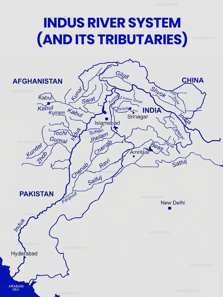
Indus River tributaries are classified into left and right bank rivers, such as Jhelum, Chenab, Ravi, Beas, Sutlej, Shyok, and Kabul. This guide explains their origin, course, and classification with a map.

Gajendra Singh Godara
8
mins read
Add a comment

Key highlights:
Left Bank Tributaries: Jhelum, Chenab, Ravi, Beas, Sutlej
Right Bank Tributaries: Shyok, Gilgit, Kabul
Source of Indus: Near Lake Mansarovar in Tibet
Flow Direction: Tibet - Ladakh - Pakistan- Arabian Sea
Major Confluence: Panchnad (Punjab region)
Important Treaty: Indus Water Treaty (1960)
One of the three major Himalayan river basins in India, the Indus River system and its extensive network of tributaries are habitats for diverse ecosystems and human settlements.
The Indus River System is also one of the world's largest transboundary river basins crossing parts of India, Pakistan, China and Afghanistan- supporting the economy of each of these regions.
This blog explores the origin of the Indus River, its tributaries, features, importance and the famous Indus River Treaty.
Join our WhatsApp Community
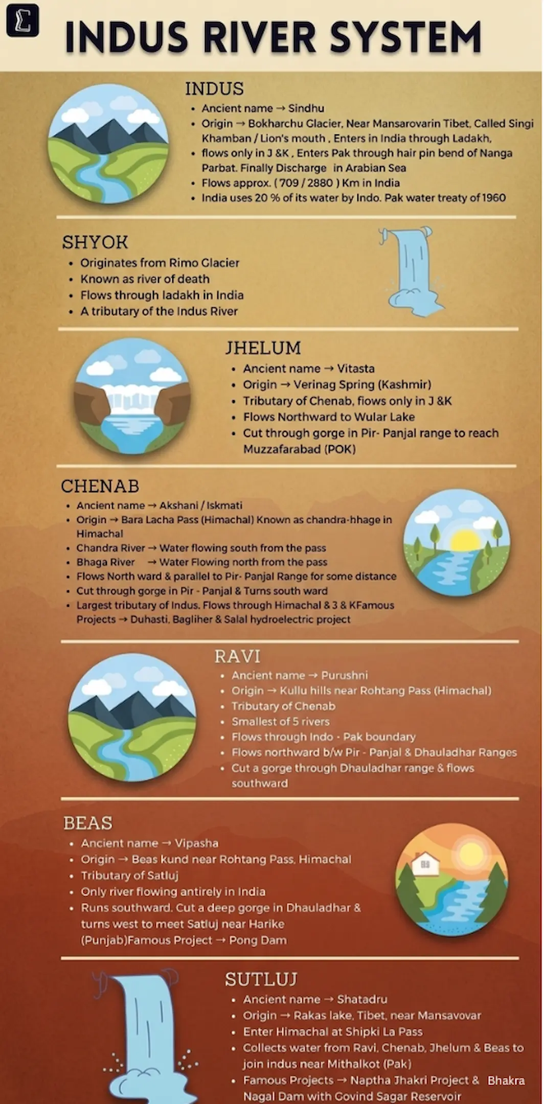
The Indus River System has a glacial origin in Tibet and flows northwest.
The Indus River's origin can be traced to a glacier near Bokhar Chu in the Tibetan region near the Kailash Mountain Range and Mansarovar Lake.
The Indus River flows northwest and enters India from the Demchok region of Ladakh.
Locally in Tibet, it is also known as "Singi Khamban" (Lion's mouth)
Flowing between the Karakoram range and the Ladakh range, it is a vital water source for the country and also affects its topography.
The Indus river originates in Tibet and finally joins the Arabian Sea. Its journey is described below:
From its origin in the Bokhar Chu glacier, the Indus River is joined by the Zanskar River in Ladakh.
Indus then flows northwest into Ladakh in India, as well as Baltistan and Gilgit in Pakistan, which is south of the Karakoram range.
Glacial waters are brought into the Indus River from the Shyok, Gilgit and Shigar rivers.
The river passes through gorges near Nanga Parbat, flowing through Pakistani regions of Punjab and Sindh before draining into the Arabian Sea.
Panjnad joins the Indus River at Mithankot.
The flow of the Indus River is seasonal, diminishing greatly in winters while flooding its banks in the monsoon months of July-September.
Add as a preferred Source on Google
The important features of the Indus river and its tributaries are:
One of the largest river systems in the world, the length of the Indus River system is 1,114 km in India and 3000 km overall.
The Indus River forms deep gorges in the Himalayas before flowing into the plains in Punjab and Sindh.
It is the habitat of the endangered blind Indus River dolphin.
It supports agriculture and biodiversity in India and Pakistan.

The tributaries of the Indus River are classified into left bank and right bank tributaries. They are listed in the table below:
Bank | Tributary Name | Origin / Source | Key Characteristic |
Left Bank | Zanskar | Zanskar Ranges | Meets Indus at Nimmu, known for the "Chadar Trek." |
Left Bank | Suru | Panzella Glacier | Flows through Kargil; significant for local irrigation. |
Left Bank | Soan | Shivalik Hills | Primary river of the Potohar Plateau in Pakistan. |
Left Bank | Jhelum | Verinag Spring (Kashmir) | Flows through Wular Lake; forms the border between India and Pakistan. |
Left Bank | Chenab | Bara Lacha Pass (Lahaul) | Formed by the confluence of Chandra and Bhaga; Largest tributary. |
Left Bank | Ravi | Rohtang Pass (Kullu) | Flows between the Pir Panjal and Dhauladhar ranges. |
Left Bank | Beas | Beas Kund (Rohtang) | Entirely within Indian territory; joins Satluj at Harike. |
Left Bank | Satluj | Rakshas Tal (Tibet) | Enters India through Shipki La Pass; feeds the Bhakra Nangal Dam. |
Right Bank | Shyok | Rimo Glacier (Karakoram) | Known as the "River of Death", it flows through the Nubra Valley. |
Right Bank | Gilgit | Shandoor Lake | Joins the Indus at Bunji; strategic northernmost tributary. |
Right Bank | Hunza | Karakoram Range | Vital for the Karakoram Highway region. |
Right Bank | Kabul | Hindu Kush (Afghanistan) | Joins near Attock; major river for the Peshawar Valley. |
Right Bank | Gomal | Afghanistan Mountains | Joins the Indus in Dera Ismail Khan, Pakistan. |
Right Bank | Kurram | Safed Koh Range | Joins the Indus south of the Kabul river confluence. |
Important Left Bank Tributaries of Indus River: Jaskar River, Suru River, Jhelum River, Chenab River, Ravi River, Beas River and Sutlej River
Important Right Bank Tributaries of the Indus River: Shyok River, Gilgit River, Hunza River, Swat River, Kunnar River, Kurram River, Gomal River and Kabul River.
Major Left Bank Tributaries of the Indus River
Left Bank Indus river tributaries, primarily the Panjnad (Jhelum, Chenab, Ravi, Beas, and Sutlej), are characterised as large, perennial rivers originating from the Himalayas. They receive water from both rainfall and snowmelt and support extensive irrigation projects in India and Pakistan.
1. Jhelum River
Origin: Originates from Chashma Verinag a deep, perennial natural spring in the Pir Panjal range, Jammu & Kashmir
Flow: Travelling approximately 725 kms through India and Pakistan, it flows through Srinagar and Wular Lake (one of the largest freshwater lakes in India)
Features:
Also known as Vitasta (Rigveda), Hydaspes (Greek), and Veth (Kashmir)
Kishanganga (Neelum) River is its largest tributary and joins the Jhelum in Jammu & Kashmir.
It ends in a confluence with the Chenab River in Pakistan.
2. Chenab River
Origin: Originates from Bara-lacha La in the Zaskar Range of Himachal Pradesh. Formed by the confluence of the Chandra and Bhaga rivers of the upper Himalayas.
Flow: Flows from Himachal Pradesh to Jammu and Kashmir in India, entering Pakistan through Sialkot.
Features:
Chenab is the largest Tributary of the Indus River
The largest tributary of the Chenab River is the Marusudar, meeting at Bhandalkot.
Ancient texts refer to the river as Asskini Chandrabhaga.
3. Ravi River
Origin: Originates from the Dhauladhar Range in the Himalayas in the Chamba district, Himachal Pradesh, near Rohtang Pass.
Flow: The 720 km transboundary river passes through Himachal Pradesh, Jammu & Kashmir, Punjab and finally joins the Chenab river near Lahore, Pakistan.
Features:
The river passes through Shahdara Bagh, which is the site of the Mughal tombs of Jahangir and Noor Jahan.
One of the Major multipurpose dams on the Indus River is the Ranjit Sagar Dam, located on this tributary.
Provides water for irrigation in India and Pakistan
It is also known as Iravati and "The River of Lahore."
4. Beas River
Origin: Originates from Beas Kund near Rohtang La Pass in Himachal Pradesh.
Flow: The 470 kms long river flows through Manali, Kullu and Kangra Valleys in Himachal Pradesh before merging into the Sutlej River in Punjab.
Features:
Known as Vipasha in ancient texts, it marked the eastern limit of Alexander the Great's campaign.
It is essential for generating hydropower, irrigation and sustaining biodiversity in the region.
5. Sutlej River
Origin: Originates close to Rakshastal Lake, Tibet
Flow: The 1,450 km river enters India through Himachal Pradesh via the Shipki La Pass and flows into Pakistan to join the Indus River.
Features:
Longest Tributary of the Indus River
Essential for irrigation and hydropower via the Bhakra Nangal Dam.
In Sanskrit, it is also known as Shatadru (or Satadree).
Right Bank Tributaries of the Indus River
The characteristic feature of the right bank tributaries of the Indus River is that they primarily originate in the Karakoram, Hindu Kush and Western Himalayan Ranges. Their source of water is glacial as well as snowmelt, and they are known for steep gradients and immense hydro-energy potential.
1. Shyok River
Origin: Originates from Rimo Glacier in the Karakoram range.
Flow: This 550 kms long river flows through the Ladakh region of India and Gilgit-Baltistan in Pakistan, where it joins the Indus.
Features:
Its name means "River of death" owing to its unpredictable flows, high velocity and frequent flash floods caused by it.
Forms a unique V-shaped bend around the Karakoram Range.
Nubra River: Main tributary of the Shyok River, which originates from the Siachen Glacier (one of the highest glacier sources)
2. Gilgit River
Origin: Originates from high alpine glaciers in Shandur Lake, Pakistan.
Flow: 240 km tributary that flows through the Gilgit valley of Pakistan and merges with the Indus River near Bunji, Pakistan.
Feature: It serves as an important water source and geographical feature in northern Pakistan.
3. Hunza River
Origin: Originates in high-altitude glaciers of the Karakoram range, formed by the glacial streams- Khunjerab River, Chapursan River and Shimshal River.
Flow: This 250 kms long tributary drains the Karakoram mountains and joins the Gilgit River in Pakistan.
Features:
The river runs along the famous Silk Route and the Karakoram Highway connecting Pakistan and China.
Home to the Artificial Attabad Lake.
Prone to flash floods and glacial outburst floods.
The Indus Water Treaty of 1960 is a significant agreement between India and Pakistan to manage the shared water resources.
It was signed on September 19, 1960, by then Indian Prime Minister Jawaharlal Nehru and Pakistani President Ayub Khan and mediated by the World Bank.
The rivers are divided as follows:
Eastern Rivers: Ravi, Beas, and Sutlej are given to India.
Western Rivers: Indus, Jhelum, and Chenab are given to Pakistan.
The treaty allows India to use western water sources for domestic, non-consumptive needs, restricted agricultural use and hydropower projects.
The treaty is considered one of the most successful water-sharing pacts in the world, offering a practical way for cooperation and conflict resolution.
Current Status: Following the Pahalgam attack of 2025, India announced that the Indus water treaty will remain in abeyance until Pakistan takes measures against terrorism.
The Indus River is of immense ecological, environmental, strategic and cultural significance in India.
Agriculture: The eastern rivers like Ravi, Beas and Sutlej support India's breadbasket agriculture in Punjab as well as Jammu & Kashmir.
Hydropower: Several rivers, like the Chenab and the Jhelum, are utilised for hydroelectricity generation by India.
Water source: As the primary water source in the arid region of Ladakh, it supports both humans and wildlife in the region.
Historical significance: It is a living reminder of the ancient Indus Valley Civilisation, which has an important role in Indian as well as World History.
Treaty: The 1960 Indus Water Treaty is a symbol of systemic governance of resources by India and Pakistan.
Frequently asked question (FAQs)
What are the major right bank tributaries of the Indus River?
What are the major left bank tributaries of the Indus River?
Which is the largest tributary of the Indus River?
Which is the Longest tributary of the Indus River?
How is water divided under the Indus Waters Treaty (1960)?
The Indus River and its tributaries are crucial in sustaining livelihoods and diverse ecosystems across borders, making it a geographically important feature. It not only acts as a water source for various purposes like other river systems, but it is also of strategic and historical importance due to the Indus Water Treaty. Its association with the Indus Valley Civilisation makes it an important topic for aspirants in History alongside Geography.


Gajendra Singh Godara is an IIT Bombay graduate and a UPSC aspirant with 4 attempts, including multiple Prelims and Mains appearances. He specializes in Polity, Modern History, International Relations, and Economy. At PadhAI, Gajendra leverages his firsthand exam experience to simplify complex concepts, creating high-efficiency study materials that help aspirants save time and stay focused.

No comments yet. Be the first to join the discussion!


