Indo-Gangetic Plains: Map, Formation, Divisions, Features
The Indo-Gangetic Plains, spanning northern India are fertile alluvial lands formed by the Indus, Ganga, and Brahmaputra rivers. Featuring Bhabar, Tarai, Bhangar, and Khadar belts, they support intensive agriculture, dense populations and are crucial for India’s economy and ecology.

Gajendra Singh Godara
8
mins read
Add a comment
Vast alluvial plains (~7.8 lakh sq. km) across northern India.
Formed by Indus, Ganga, Brahmaputra rivers and tributaries.
Geomorphology: Bhabar, Tarai, Bhangar, Khadar belts.
Fertile soils; core of India’s rice-wheat belt.
Supports 40% of India’s population and major cities.
Faces flooding, groundwater depletion, and soil salinization.
The Indo-Gangetic Plains, also called the Great Northern Plains, are one of the world’s largest and most fertile alluvial regions. Formed by the Indus, Ganga, and Brahmaputra river systems, they stretch across northern India as a vast lowland between the Himalayas in the north and the Peninsular Plateau in the south.
Features of the Indo-Gangetic Plains
Feature | Description |
Type of Landform | Extensive alluvial plain formed by deposition from rivers over millions of years |
River Systems | Indus, Ganga, Brahmaputra and their major tributaries (Sutlej, Yamuna, Ghaghara, Kosi, Teesta, etc.) |
States Covered | Punjab, Haryana, Rajasthan (eastern parts), Uttar Pradesh, Bihar, West Bengal, Assam |
Total Area | Approximately 7.8 lakh sq. km |
Length & Width | ~2,400 km long, 150–300 km wide |
Relief / Topography | Flat, low-lying terrain with a very gentle slope from north to south |
Soil Type | Fertile alluvial soils: Bhangar (older alluvium) and Khadar (new alluvium) |
Alluvial Depth | Up to 6,000–6,100 m in central Ganga basin |
Drainage Pattern | Dendritic, dominated by perennial rivers; meandering with oxbow lakes in middle plains |
Flooding | Frequent in Ganga and Brahmaputra basins; especially in Kosi (Sorrow of Bihar) and Brahmaputra valley |
Agricultural Importance | Core of India’s rice-wheat belt; major contributor to national food security; cropping intensity >155% |
Population Density | One of the most densely populated regions globally; supports ~40% of India’s population |
Special Features | Includes Five Doabs of Punjab, Bet lands, Chars in Bengal, and Majuli Island in Assam; strategic trade and cultural corridor |
Join our WhatsApp Community
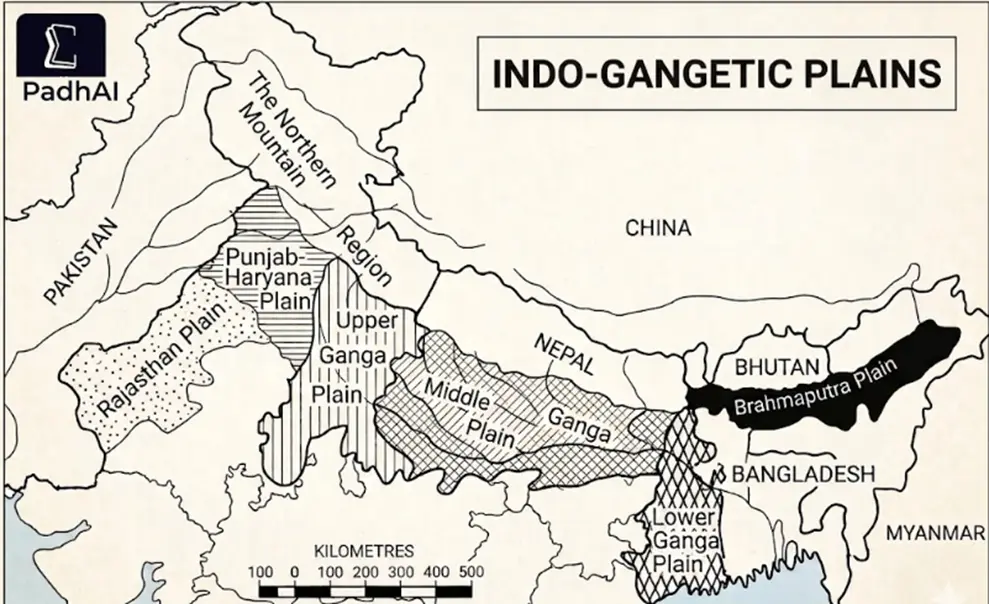
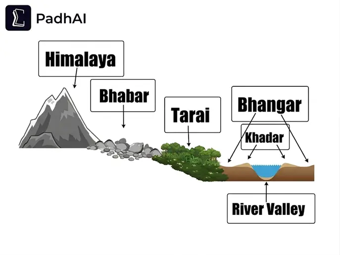
The Indo-Gangetic Plains are not uniform. Based on sediment size and groundwater conditions, they are divided into four distinct belts from north to south.
Bhabar – The Porous Belt
Tarai – The Marshy Zone
Bhangar – The Old Alluvium
Khadar – The New Alluvium
Comparison table of the belts
Feature | Bhabar | Tarai | Bhangar | Khadar |
Location | Along Shiwalik foothills | South of Bhabar | Elevated terraces above floodplains | Low-lying floodplains |
Width | 8–16 km | 15–30 km | Extensive | Extensive |
Soil Type | Coarse (pebbles, boulders) | Marshy, fine sediments | Old alluvium | New alluvium |
Water Behavior | Streams disappear underground | Streams re-emerge | Moderate retention | High moisture |
Key Feature | High porosity | Waterlogged, forested | Presence of kankar | Annual silt deposition |
Fertility | Poor; limited cultivation | Moderate; Reclaimed for farming | Less productive | Highly productive |
Soil Issues | Rocky terrain | Waterlogging | Salinity (reh/kallar) | Flood risk |
Human Use | Forestry, grazing | Intensive agriculture | Settlements, mixed farming | Intensive agriculture |
Add as a preferred Source on Google
The Indo-Gangetic Plains are the youngest physiographic division of India, formed during the Cenozoic Era as a result of the Himalayan mountain-building process (orogeny). Their origin is closely linked to tectonic activity and long-term sediment deposition.
1. Formation of the Himalayan Foredeep
Around 65 million years ago, the Indian Plate collided with the Eurasian Plate.
This led to the uplift of the Himalayas and the creation of a foredeep- a long structural depression between the mountains and the Peninsular Plateau.
Initially, this depression was occupied by the Tethys Sea.
2. Sedimentation and Infilling
Rivers like the Indus, Ganga, and Brahmaputra carried large amounts of sediments from the Himalayas.
Peninsular rivers (e.g., Chambal, Betwa) also contributed deposits from the south.
Over millions of years, this depression was filled through aggradation:
Coarse sediments → deposited near foothills (Bhabar)
Fine sediments → spread across plains (Khadar region)
The Indo-Gangetic Plains are divided into four major regions based on relief, drainage, and sedimentation patterns, with a clear transition from coarse deposits in the west and north to finer, more dynamic alluvium in the east.
Punjab–Haryana Plains (Watershed Region)
Extent: ~640 km length, ~300 km width
Delhi–Aravalli Ridge acts as the water divide between Indus and Ganga systems
Characterized by interfluves (Doabs)
Five Doabs (North to South):
Bist-Jalandhar Doab (Between Beas–Sutlej)
Bari Doab (Between Beas–Ravi)
Rechna Doab (Between Ravi–Chenab)
Chaj Doab (Between Chenab–Jhelum)
Sind Sagar Doab (Between Jhelum–Indus)
Key Features:
Alluvial fans along Shiwalik foothills
Bet lands: Flood-prone Khadar
Dhayas: Broad floodplains with steep margins
Chos: Seasonal streams causing erosion and gullying
Rajasthan Plains (Arid Extension)
Area: ~2 lakh sq. km | Elevation: ~325 m
Western arid extension of the plains
Key Features:
Marusthali: Desert with dunes (dhrians) and rocky surfaces (hammada)
Shaped by aeolian (wind) processes
Bagar: Semi-arid zone with ephemeral streams
Luni Basin: Inland drainage ending in Rann of Kutch
Saline lakes (playas): Sambhar, Didwana, Degana, Kuchaman
Ganga Plains (Core Region)
Largest unit (~3.75 lakh sq. km)
Fine alluvium with meandering rivers
Supports intensive agriculture
Upper Ganga Plain
Location: Western Uttar Pradesh
Area: Ganga–Yamuna Doab, Rohilkhand
Boundaries: Yamuna to Lucknow–Faizabad line
Bhurs: wind-deposited sandy ridges
Well-developed doabs and irrigation
Middle Ganga Plain
Location: Eastern Uttar Pradesh and Bihar
Area: Awadh, Mithila, Magadh
Boundaries: Eastern UP to Rajmahal Hills
High river instability and flooding
Kosi River shifting (>100 km in ~200 years)
Formation of oxbow lakes
Lower Ganga Plain
Location: West Bengal
Area: Deltaic region
Boundaries: Rajmahal Hills to Bay of Bengal
Chars and bils found here
Natural levees
Part of the Ganga–Brahmaputra Delta formed by heavy sediment deposition
World’s largest delta, with Sunderbans mangroves
Habitat of the Royal Bengal Tiger
Brahmaputra Valley (Assam Plains)
Narrow valley (~80 km wide)
Bounded by Himalayas, Patkai Hills, Meghalaya Plateau
Key Features:
Braided channels due to heavy sediment load
Numerous river islands (chars)
Majuli: largest riverine island
Antecedent river system
Aggradational plain with continuous deposition
High sediment load from young Himalayas
Raised riverbed leads to severe floods
The Delhi Ridge
The Delhi Ridge is the northernmost extension of the ancient Aravalli Range (Precambrian fold mountains), primarily composed of metamorphic quartzite.
It acts as the Great Indian Watershed, separating:
Indus River System: flows west and southwest
Ganga River System: flows east and southeast
Without this ridge, northern India’s drainage pattern would be fundamentally different.
Acts as a barrier against hot desert winds from Rajasthan
2025–26 updates emphasize protecting the Morphological Ridge, areas with same geology but not officially notified as forests
The Sunderbans Delta
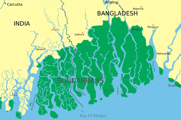
The Sunderbans, the terminal lobe of the Indo-Gangetic Plains, forms at the confluence of the Ganga, Brahmaputra, and Meghna rivers.
Active Delta: Constant silt deposition creates new land, unlike moribund regions in West Bengal
UNESCO World Heritage Site – unique biodiversity
Biosphere Reserve – focuses on coexistence with Royal Bengal Tiger
Estuaries and Mudflats: Tidal creeks flood forests; only canopy visible at high tide
Pneumatophores: Blind roots of Sundari trees (Heritiera fomes) grow upward in saline, oxygen-poor soils
Delhi Ridge vs Sunderbans Delta – Quick Comparison
Feature | Delhi Ridge | Sunderbans Delta |
Geological Origin | Ancient Aravalli (Precambrian) | Recent Alluvial (Holocene/Anthropocene) |
Primary Function | Water divide & desert barrier | Cyclone buffer & carbon sink |
Key Flora | Tropical dry thorn forest | Mangrove (halophytes) |
Topography | Rocky outcrops (Quartzite) | Tidal mudflats & estuaries |
Modern Threat | Urban encroachment | Sea-level rise & salinity |
The Indo-Gangetic Plains (IGP) are the lifeline of northern and eastern India. Covering only about 25% of the country, they support nearly 40% of India’s population due to their fertility, connectivity, and historical significance.
1. Agricultural Powerhouse
Major Crops: Rice and wheat contribute heavily to India’s food security
2025-26 Production: 150.18 million tonnes of rice and 117.94 million tonnes of wheat
Cropping Intensity: Over 155%, allowing multiple crops per year (Kharif, Rabi, Zaid)
Agri-Tech Initiatives: AgriStack (Digital Public Infrastructure) targets UP and Bihar for better land and crop management
2. Civilizational Corridor
Historical Heartland: The plains formed Madhyadesha, the cultural and political core of ancient India
Urban Hubs: Major cities like Delhi-NCR (30+ million) and Kolkata (22+ million) lie here
Connectivity: Flat terrain allowed the densest railway and road networks, making the plains a hub for trade and movement
3. Strategic & Economic Significance
Rivers as Lifelines: Indus, Ganga, and Brahmaputra rivers ensure water availability, fertile soils, and inland navigation
Green Revolution Core: Punjab, Haryana, and western UP became the breadbasket of India
Economic Activity: High population density supports industrial clusters, market hubs, and logistics networks
The Indo-Gangetic Plain (IGP) is currently categorized as one of the most "environmentally stressed" regions globally. Its flat topography and high population density create a unique set of ecological pressures.
Challenge | Primary Driver | Impact Zone | Strategic Response / Programmes |
Air Pollution | Winter inversion, stubble burning | Punjab to West Bengal | NCAP, Crop Residue Management Schemes, EV promotion, Industrial emission controls |
Groundwater Depletion | Over-extraction for irrigation | Punjab, Haryana, Western UP | Atal Bhujal Yojana, Micro-Irrigation, Jal Jeevan Mission |
Soil Salinization / Desertification | Waterlogging, chemical overuse | Upper & Middle Ganga Plains | Natural Farming, Nano-Urea, Soil Health Card Scheme |
Hydrological Instability | Glacial melt, river avulsion | Bihar, Eastern UP, Brahmaputra basin | Flood Zoning, Embankments, River Management Boards, NFMP |
Deltaic & Coastal Stress | Sea-level rise, salinity intrusion | West Bengal, Sunderbans | Mangrove restoration, Biosphere Reserve management, ICZM, Coastal Embankments, Cyclone Shelters |
Q1. [2023 - Geography Optional] "Discuss the problems of floods and their management with special reference to the Indo-Gangetic Plain." (250 words)
Key points to include: River avulsion (Kosi), encroachment of floodplains (Yamuna), and the impact of climate-induced erratic monsoons.
Frequently asked question (FAQs)
What are the Indo-Gangetic Plains?
Where are the Indo-Gangetic Plains located?
How were the Indo-Gangetic Plains formed?
Why are the Indo-Gangetic Plains important?
Which rivers flow through the Indo-Gangetic Plains?
The Indo-Gangetic Plains are the socio-economic and ecological backbone of northern India. They reflect the dynamic interplay of Himalayan uplift and river deposition.
The plains are a vital lifeline; understanding their geography, resources, and challenges links physical landscapes to policy, agriculture, and climate solutions.


Gajendra Singh Godara is an IIT Bombay graduate and a UPSC aspirant with 4 attempts, including multiple Prelims and Mains appearances. He specializes in Polity, Modern History, International Relations, and Economy. At PadhAI, Gajendra leverages his firsthand exam experience to simplify complex concepts, creating high-efficiency study materials that help aspirants save time and stay focused.

No comments yet. Be the first to join the discussion!


